
4 Billington St, Plymouth, MA 02360, USA
Plymouth Parks & Forestry: 508-830-4162, ext. 12116
Owned By: Town of Plymouth
Plymouth’s 4-acre Billington Street Park features a charming covered bridge, views of Town Brook, a grassy picnic area, interpretive signage, and two rain gardens. The park is the site of the former Billington Street Dam, which was removed in 2002. It was the first coastal dam removal in Massachusetts!
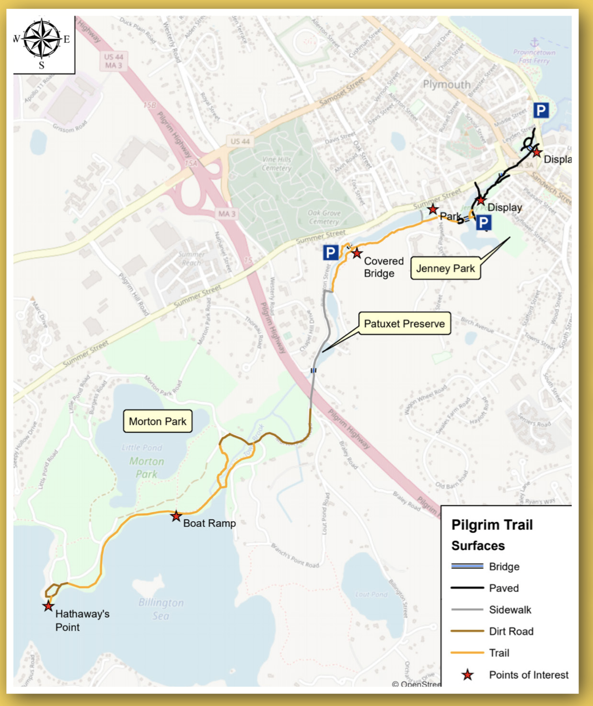
The park connects directly to the 1.5-mile Town Brook Trail. Heading upstream, you can walk along the water’s edge to the Town Brook Patuxet Preserve. Heading downstream, you’ll pass through Holmes Playground and Skate Park, Town Brook Park, the Plimoth Grist Mill, Brewster Gardens, and Pilgrim Memorial State Park with numerous river views.
On the map linked here, the park is located at the “Covered Bridge” star. The spot was known historically as the Third Water Privilege on Town Brook, and the bridge is sometimes known as the Boy Scout Bridge.
Hunting is not permitted on this property.
FISHING ADVISORY: It’s important to know that some of our freshwater fisheries are contaminated with mercury, PFAS and/or other concerning substances. The Massachusetts Department of Public Health maintains an online database with up-to-date advisories regarding fish consumption, sorted by location. We recommend you consult this valuable resource when planning a fishing excursion.
Features
According to signage on site, the Billington Street Dam was constructed in in the late 1790s as a foundation for the Holmes and Packard Anchor Forge Mill. The mill’s footprint, at nearly 500 square feet, spanned the brook. Marine anchors were forged there from 1800 to 1815. From 1815 to 1844, the Russell Iron Company manufactured nails and tacks there, and then in 1854, Plymouth Mills took over, producing tacks, nails, rivets, patterns and various machinery components, until it ceased operations in 1926. The mill property subsequently passed through several private owners and was destroyed by fire in the late 1960s.
The earthen dam that remained after the fire was 70 feet long and 110 feet wide. A 4′ x 67′ metal culvert under the dam permitted the brook to flow through. A fish ladder was installed, but it did not function. Looking upstream from the wooden bridge at this time, you would have seen an impoundment (pond), not a brook.
The dam at Billington Street Park was removed by 2002 by Town Brook Partners, which included the Town of Plymouth and a coalition of federal, state, non-profit and private sector agencies. This was the first coastal dam removal in Massachusetts. Natural river function was restored, allowing migratory fish such as herring to reach their spawning grounds in Billington Sea. According to an article on the Town of Plymouth’s website, it took a long time for centuries of accumulated silt to wash out of the brook, and during the process, various “artifacts” were revealed, including abandoned rowboats, traces of old mills, and a 40-year-old stolen car! Ultimately, a total of five dams were removed on Town Brook, concluding with the Holmes Dam in 2018-2019. For additional details, check out this StoryMap.
Prior to European settlement, the Patuxet Wampanoag established a pathway along Town Brook, known now as the Namassakeeset Trail. There was a Patuxet Wampanoag settlement and/or burial ground on Watson’s Hill, on the southeast side of Jenney Pond. It was known as Cantaugheantiest, meaning “planted fields.” The Treaty of Cantaugheanta, a verbal agreement, was made by 60 Wampanoag tribe members and 30 Pilgrims in April 1621, and is considered to be the first treaty between Europeans and Native Americans in the New World.
Please bear in mind that Native American cultures often favor oral histories to written ones. Much of what’s recorded about the history of the South Shore is from the perspective of European settlers. It’s not the whole story. To learn more about our local tribes, we encourage you to interact with their members. The Mashpee Wampanoag tribe and the Herring Pond Wampanoag share information on their websites.
When the Pilgrims arrived in Plymouth in 1620, they built their homes close to Town Brook, to make use of its fresh water supply. Town Brook is probably the spot where, in colonial times, it was reported that the herring were so numerous, one could “walk across their backs” to the other side of the stream.
When industry began in the area, mills and factories harnessed water power at naturally-occurring “falls of water” along the brook. Rights to these valuable sites were known as “water privileges.” For example, one of the colony’s first corn mills was built (prior to 1636) by Stephen Dean, at today’s Plimoth Grist Mill, known then as the Sixth Water Privilege. There are historic markers and detailed informational kiosks at the sites of the First, Second, Third, and Fourth Water Privileges, where you can read about such local industries as leather tanning, iron rolling/slitting, processing tobacco, as well as mills and factories producing thread, cloth, windows, nails, tacks, rivets, anchors, patterns, machinery components, and other iron goods. Look for stone walls and other remnants from the brook’s industrial age.
Until the 19th century, fish ladders were required at all dams on Town Brook. This practice largely fell by the wayside for a time, when industry prevailed. By the early 20th century, herring and other migratory fish were sometimes captured in a trap at the mouth of the brook and transported over land to their Billington Sea spawning grounds! Fishways were reintroduced between 1920 and 1940, but it wasn’t until the dams were removed in the 21st century that Town Brook began to see a resurgence of its anadromous fish population.
Trail Description
This park is located close to the midpoint of Town Brook Trail. The 1.5-mile trail officially begins farther up Billington Street, at the site of the Second Water Privilege. However you can follow the sidewalk even farther to visit the Town Brook Patuxet Preserve at the historic First Water Privilege, and continue 0.25 miles farther, to Morton Park. This upstream section is not paved, but that is likely to change.
From its official start on Billington Street, the trail extends through the woods along the edge of Town Brook past numerous historic markers. A red wooden covered bridge provides passage across the brook to the site of the Third Water Privilege, where the Billington Street Dam once stood, now Billington Street Park.
Downstream of the park, the trail continues along the edge of the brook, and eventually turns to gravel, extending over a ridge with some captivating views of the water and homes below, as well as Holmes Park, also known as the Plymouth Skate Park. At the edge of the trail, across the brook from Holmes Park, there is a parking area for 8 cars. Cross Newfield Street to follow the remainder of the trail, the rest of which is paved. It zigzags down a small hill, crosses Willard Place, and enters Town Brook Park via an arched wooden bridge. On the other side of the park, it continues behind the Plimoth Grist Mill, and along the edge of the brook as it flows out to sea, bypassing the busy roads nearby. At its terminus in Plymouth Harbor, the trail connects directly with Brewster Gardens and Pilgrim Memorial State Park.
Habitats and Wildlife
This small grassy park has open areas along with woodlands composed primarily of maple, pine, oak, cherry, birch and black walnut. Town Brook flows through the property. It finds its source in the 269-acre freshwater pond known as the Billington Sea, and flows for 1.5 miles before emptying into Plymouth Harbor.
The brook is home to a herring run on the rebound! Every spring, thousands of herring swim upstream to their spawning grounds in the Billington Sea. In 2003, about 7,000 herring were counted here. In 2016, there were nearly 200,000! This is thanks largely to the removal of five local dams that impeded fish passage. Mass Wildlife stocks Town Brook with brown trout.


Historic Site: Yes
Park: Yes
Beach: No
Boat Launch: No
Lifeguards: No
Size: 4 acres
Hours: Dawn to Dusk
Parking: Limited roadside parking (5 vehicles) at 4 Billington Street.
Cost: Free
Trail Difficulty: Easy
Facilities:
Benches, picnic tables, covered bridge, interpretive signage, historic markers, trash receptacles. Geocache location.
Dogs: Dogs must remain on leash. Always clean up after your dog!
Boat Ramp: No
ADA Access: No
Scenic Views: Yes
Waterbody/Watershed: Town Brook