
The NSRWA is working with the towns of Duxbury and Marshfield, the Mass Division of Ecological Restoration (DER) and the MassBays National Estuary Partnership, private dam owners and other stakeholders to holistically improve and restore the health of the South River and its habitat for migrating species such as river herring, eel and shad as well as freshwater native species such as Eastern brook trout.
The restoration of the South River is complicated by existing residential and park development in the river’s floodplain, and altered river flows from numerous dams along the river. As a result, it has taken over a decade but we are finally making progress and the first dam was removed at Veterans Memorial Park in January 2025, and the Temple St Dam removal should be complete Fall 2026.
Search our News page for updates on current projects and our ongoing efforts to restore and reconnect the South River, and check out the South River: Past, Present and Future presentation that was part of our 2026 WaterWatch Lecture Series.
Background
The South River is a 15-mile river that with its headwaters at Round Pond in Duxbury. It flows through Duxbury and Marshfield, and is a tidal estuary to Veterans Memorial Park Dam, 8.8 miles from Massachusetts Bay. There are currently two dams on the South River mainstem – Chandlers Pond Dam and Temple St Dam – along with multiple cranberry bogs. The South River has an active river herring and shad run as well as pockets of isolated Eastern brook trout in headwater tributaries.
Veterans Memorial Park Dam – Removed!

The first impediment on the South River was a dam at Veterans Memorial Park, 8.8 miles from the ocean, owned by the Town of Marshfield. It had a pool and weir fish ladder that passed very limited numbers of fish each season.
In January 2025, the dam and fish ladder were removed, which would not have been possible without the hard work and persistence of the Town of Marshfield and local veterans. Park improvements – including ADA accessibility and upgrades to the park features that honor the towns’ veterans – will likely run through spring 2026.
NSRWA Citizen Scientists will continue monitoring the herring run and working with Massachusetts Division of Marine Fisheries to ensure that adequate flows are provided for fish passage.
To learn more about the process of removing Veterans Memorial Park Dam, watch this video produced by Marshfield Community Media.
Chandlers Pond Dam
The next upstream impedimen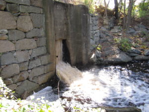 t to fish passage is Chandlers Pond dam, 9.5 miles from the ocean. Chandlers Pond Dam is on private property and has a primary spillway on a concrete dam structure that is controlled with flashboards. There is also a secondary outlet that provides an additional release during periods of high flows. These two outlets separate the South River into two channels as it flows out of the pond, then reconnect downstream before the river flows into Veterans Memorial Park. Chandlers Pond Dam is in poor shape, with vegetation on the dam crest, evidence of crumbling stonework and previous overtopping events.
A 2015 study, paid for by DER, examined the impacts on the South River’s flow from Chandler Pond down to Veterans Memorial Park under existing and alternative dam removal scenarios. For the last decade, NSRWA has been working with DER and landowners to find a design that will mary goal is to restore fish passage without impacting downstream flooding as Tom Shield’s house is downstream in the floodplain and experiences flooding under today’s conditions.
Temple Street Dam
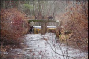 The final barrier on the South River is the Temple Street Dam, owned by the Town of Duxbury and slated for removal in 2026. The Temple Street Dam consists of an earthen berm with a 2-chamber concrete spillway. Phillips Brook – a tributary to the South River – enters upstream of Temple Street dam and has been documented as brook trout habitat by Massachusetts Division of Fisheries and Wildlife. The goals of this project are to restore fish passage, improve habitat and reduce the maintenance burden on the Town. Removal of the Temple Street Dam will reconnect an additional 7 miles of stream and restore 6 acres of open water wetland.
Feinberg and Garside Bogs
The Feinberg Bog was acquired in 1971 by the Town of Duxbury as 100 acres of conservation land and contains ~0.3 miles of stream. The bog has flumes at the upstream and downstream end; the berm adjacent to the downstream flume has failed due likely to overtopping and clogging due to beaver activity. The 61-acre Garside Bogs were acquired by the Town of Duxbury for conservation land in 1979. There are upstream and downstream flumes at this site that could potentially cause impediments to flow should they collapse. Much like the Feinberg Bogs and Temple Street Dam, the Garside Bog flumes are popular frameworks for beavers constructing dams, and there is ample evidence onsite of repeated flow restoration efforts through beaver dam removal.
- 2026 WaterWatch Lecture Series
- Education
- Community Programs
- Estuary Explorers
- River Adventures Camp
- School Programs
- Workshops and Conferences
- Healthy Rivers
- Dam Removals
- Indian Head River Restoration
- South River Restoration
- South River Restoration
- Third Herring Brook Restoration
- Improving Water Quality
- Shellfish Beds
- Streamflow Restoration
- First Herring Brook Restoration