
Owned By: Town of Norwell
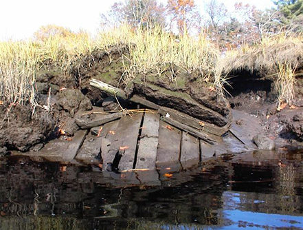
The North River Ferry Wreck, located on the banks of the North River in Norwell, is a historical artifact and must not be disturbed. What remains of a North River ferry boat can only be viewed from the northern bank of the river at dead low tide.
Until 2019, this landmark was referred to in our publications as “Gundalow.” A gundalow is a small barge employed in the harvesting of salt marsh hay. Local lore claimed (incorrectly) that the wreck of the North River Ferry was a gundalow.
Features
According to Maritime Archaeologist/Historian Paul F. McCarthy, this vessel probably was built in a North River shipyard — such as the Brooks-Tilden Yard, directly across the river, on the Marshfield side. It was approximately 19 feet long and 9 feet wide, sufficient to carry a horse and team.
D. Foster Taylor, an amateur maritime archaeologist from Quincy, described in a 1939 journal how he took measurements of the vessel. He used a steel rod to plumb the marsh over the wreck, measuring its approx. length. He measured the bow, which protruded from the bank for the breadth of the vessel. Its depth of hold was a mere 2 feet.
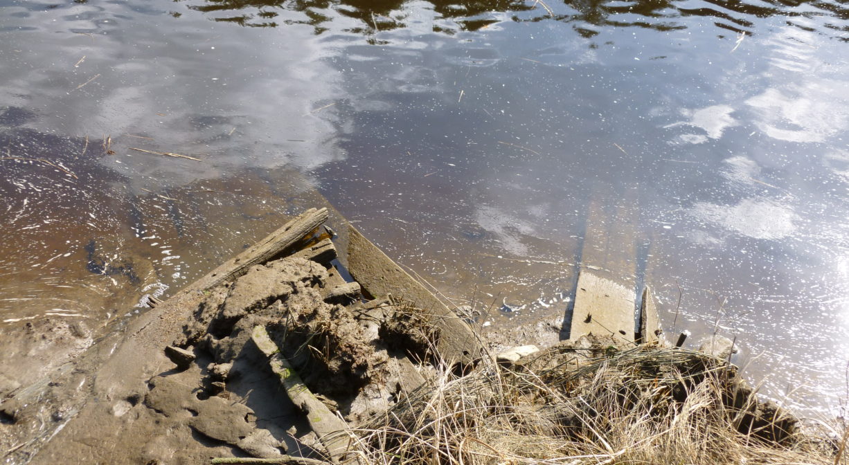
McCarthy writes, “I have been monitoring its steady decay for the past 18 years. It currently presents a few large hull timbers most of which lie in the shallows of the bank, and regrettably difficult to see from a pontoon boat.” In his 1928 book Old Time Anecdotes of the North River & the South Shore, Joseph Foster Merritt described the wreck as follows. “The old ferry that did service here was hauled up in a ditch on the Thomas meadow, and for many years parts of it could be seen sticking out of the mud.”
Beginning around 1644, Elisha Bisbee of Scituate operated a ferry at this site. His son kept a tavern nearby. Bisbee’s Ferry was also known as The Upper Ferry. Later, when the Oakman family took over, it was known as Oakman’s Ferry (1760-1770). John Tolman was the last person to operate the ferry, beginning in 1770. The site was also a landing for packet ships. Tolman became the toll keeper when the first bridge at this site was constructed, in 1801. It was a drawbridge, which was necessary to permit the passage of the large vessels built in the shipyards upriver. After Tolman, Hatch Tilden became the toll collector. He lived in a house to the east of the bridge on the Marshfield side, and held this position for 40 years.
In 1850, when sufficient tolls had been collected to settle any remaining construction debts, a jubilee was held, and crossing the bridge became free of charge. The bridge was replaced in 1898, and rebuilt again in 1917, after sustaining significant storm damage. A subsequent bridge, constructed in 1961 or 1972, stood for many years. It was a drawbridge, but the draw mechanism did not actually work! Today’s bridge was constructed in 2010.
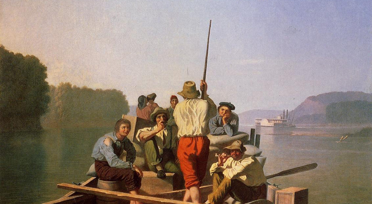
Photos of the wreck are used with the permission of Paul F. McCarthy, who retains the copyright. The older one was taken in 2003 and the newer one in 2011. The disintegration over those 8 years is plainly evident in the photos. Painting is by George Caleb Bingham, from Missouri. It shows a ferry similar in size to the North River Ferry Wreck.
This land is within the region of the Massachusett (or Massachuseuk) Native American tribe. For thousands of years, the land today known as Norwell was inhabited by indigenous people who grew crops, foraged, hunted, and fished in the Assinippi and North River areas. Circa 1617, a major outbreak of disease decimated an estimated 90% of the native population in New England. Descendants of these original inhabitants are living here today. They are known as the Mattakeesett Tribe of the Massachusett Indian Nation, the Massachusett Tribe at Ponkapoag, the Herring Pond Wampanoag, and the Mashpee Wampanoag tribe.
Trail Description
No trails. The ferry wreck is located in the second tidal ditch upstream from the bridge, on the Norwell side of the river, just upstream of the Union Street Bridge. Water access only.
Habitats and Wildlife
The North River rises from marshes and springs in Weymouth, Rockland and Hanson. It is approximately 10 miles in length, with its source at the confluence of the Indian Head River (Hanover) and Herring Brook (Pembroke). From there it flows through the towns of Hanover, Pembroke, Marshfield, Norwell, and Scituate to the Atlantic Ocean between Third and Fourth Cliffs, draining approximately 59,000 acres along the way.
Historic Site: Yes
Park: No
Beach: No
Boat Launch: No
Lifeguards: No
Hours: Dawn to Dusk
Parking: Water access only. Put in your canoe or kayak across the river at the Marshfield Launch / Brooks Tilden Shipyard.
Cost: Free
Dogs: No
Boat Ramp: No
ADA Access: No
Scenic Views: Yes
Waterbody/Watershed: North River