
720 State St, Hanson, MA 02341, USA
Town of Hanson: (781) 294-4119
https://hike.hanson-ma.gov/rocky-run.html
Owned By: Town of Hanson
The Rocky Run Conservation Area is a small but fascinating 19-acre property — beautiful, and rich in history. Jointly owned by the Town of Hanson and the Plymouth County Conservation Commission, it is situated at the confluence of the Indian Head River and Rocky Run Brook. It offers about a mile of its own trails, plus direct links to the adjacent Tucker Preserve in Pembroke, and Hanover’s Indian Head River Trails across the river.
Hunting is not allowed on this property.
Features
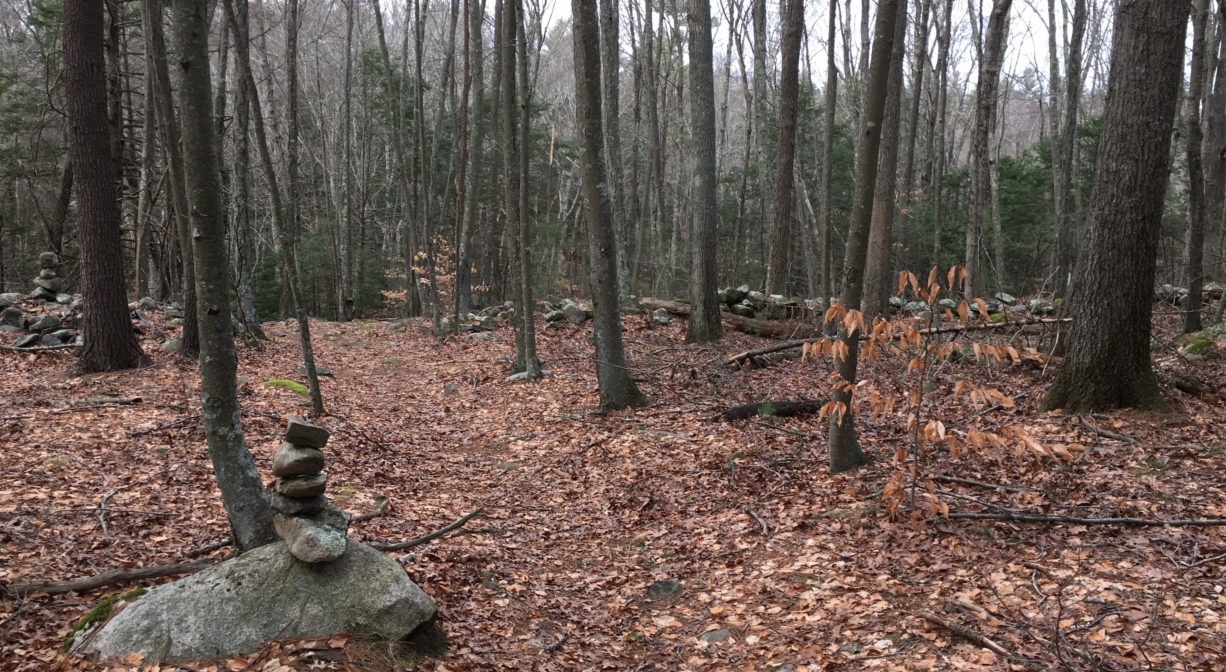
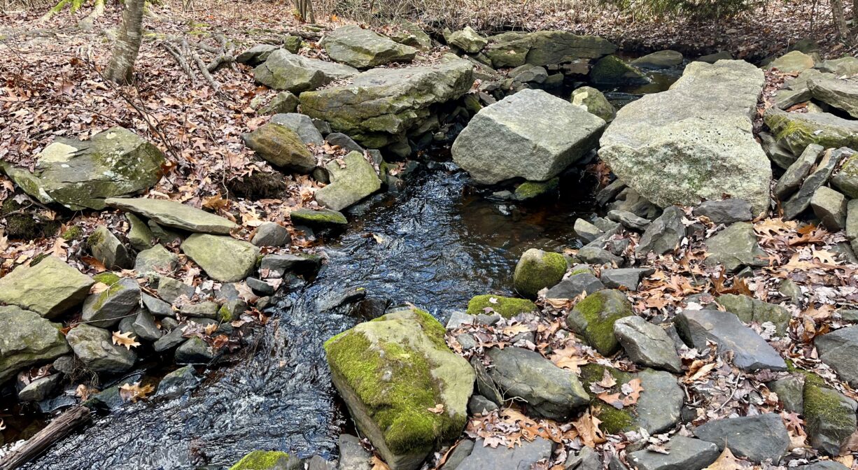
The Rocky Run Conservation Area is small, but it’s a very beautiful spot, and well worth the visit. There are captivating views of both the Indian Head River and Rocky Run Brook. Narrow footpaths extend up and down ridges along the water’s edge. Wider cart paths explore the interior. Within the parcel are the remains of three different stone dams, revealing the property’s industrial past.
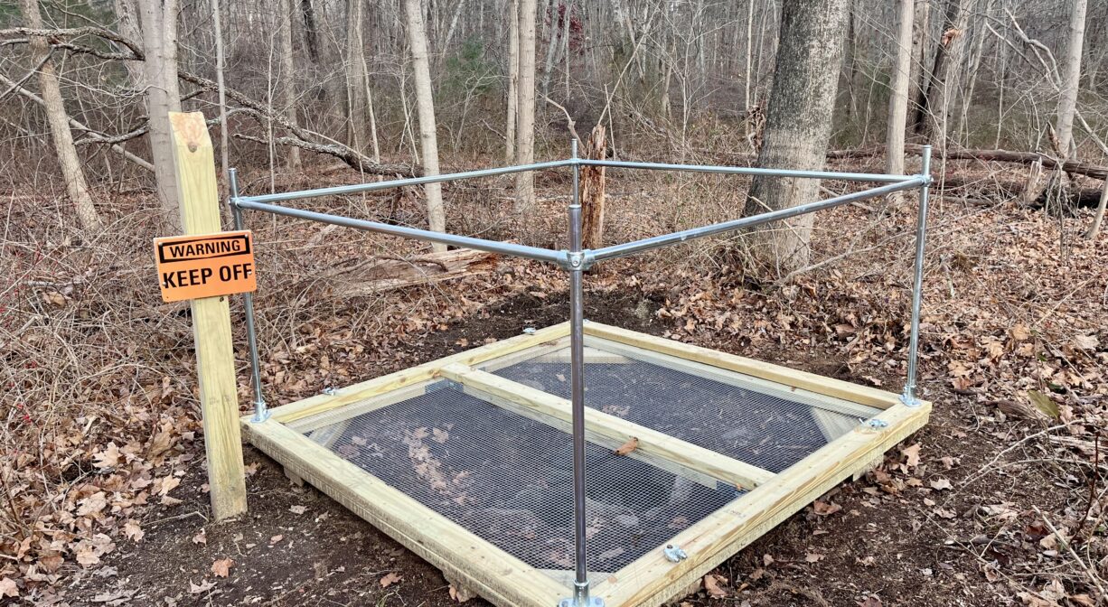
Rocky Run Brook flows from Hanson into the Indian Head River, a little bit downstream of Cross Street (Hanover) / State Street (Hanson). One of Colonel Jesse Reed’s tack factories was located on Rocky Run Brook, and before that a mill operated by Isaac Buck produced wooden ware such as bowls, trays and skimmers. A short distance down the trail from State Street, on the left, there is a dry stone well, probably from the 1700’s or 1800’s. As a safety precaution, a platform has been built over it.
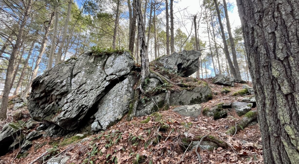
Also look for Dwelly Rock, an enormous boulder. A good way to find it is — if you enter the property from State Street — follow the suggested route below, and after you cross Rocky Run Brook, continue on the trail and look to your right for a large, long oval-shaped boulder. Climb up on top of it, and you’ll find the words “Dwelly 1875” engraved there. Dwelly once operated an iron forge nearby.
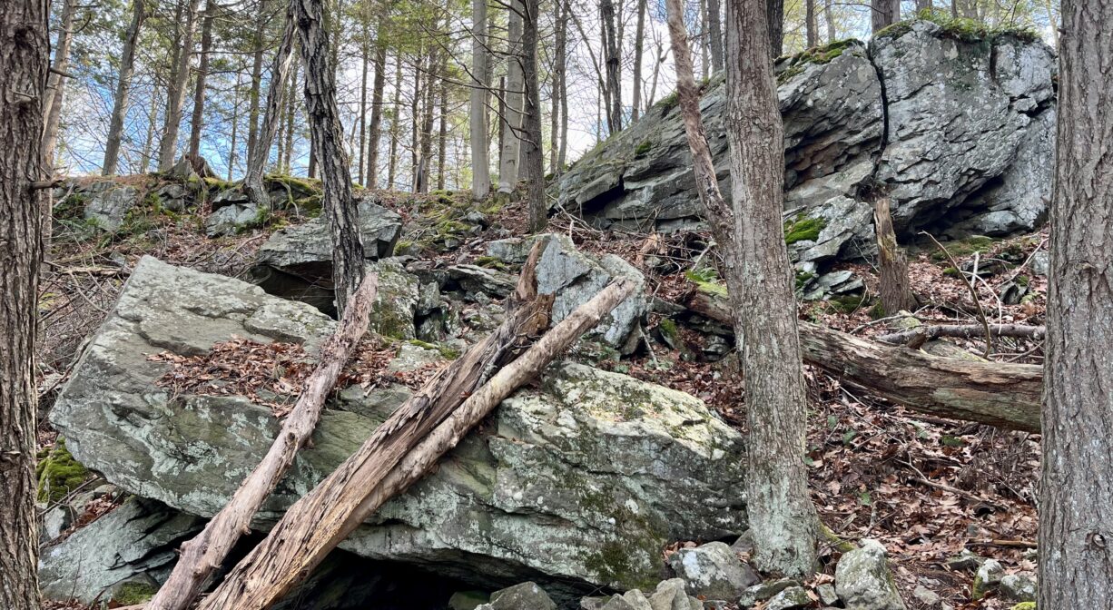
The lowest elevation point in the Town of Hanson is located within this property, at the foot of the steep bedrock cliffs. Just 25 feet above sea level, it’s a spot from which stone was once quarried for use in building dams, factories and homes nearby. The impressive cliffs are unique — there’s nothing else in Hanson quite like them.
From the parking area on State Street, look across to the pond. While it is relatively quiet today, historically it was a very busy spot. According to Barry’s Historical Sketch of Hanover, in 1720, Capt. Josiah and Benjamin Stetson were granted 2 acres to erect a dam on the Indian Head River and establish a forge and finery here. It was known as Barstow’s Forge, and later Sylvester’s. According to Barbara Barker’s “Focus on History” column, in 1853, E. Phillips & Sons established a large tack factory on site. There were more than a dozen buildings and two furnace stacks. This was succeeded by the WWI-era Atlas Tack Company. Nearly all of the factory buildings have been torn down, but one currently (2026) houses Myette’s store. NSRWA is working with local, state and federal officials to explore the removal of the remains of the now-obsolete industrial dam, which prevents migratory fish from swimming upstream to their spawning grounds.
This land is within the region of the Massachusett (or Massachuseuk) Native American tribe. The Mattakeeset band of the Massachusett lived for thousands of years in the North River watershed. Their village included most of today’s Pembroke and Hanson. To learn more about local Native American tribes, we encourage you to interact with their members. The Massachusett tribe at Ponkapoag and the Mattakeeset band of the Massachusett share information on their websites.
Trail Description
Together with the Tucker Preserve, the Indian Head River Trails, Ludden’s Ford Park in both Pembroke and Hanover, and the Mattakeeset Trail at the Hanover Public Launch, the Rocky Run Conservation Area is part of a network of trails that leads up one side and down the other side of the Indian Head River. The 4+-mile hike can be physically demanding — some of the ridges are steep! It can also be confusing, as some of the trails are not clearly marked. However, once you know the route, it is a fascinating place to explore.
Within Rocky Run, the loop trail is marked with red blazes. The upland trail extends for about 0.6 miles. There is an unmarked but well-trod trail through the lowlands as well, of about equal length.
Suggested route: As you embark on the trail from State Street, look to the left for the wooden structure that covers a dry stone well (closed off for safety). The trail continues up a hill. Along the way, look for a tree with four trunks, growing around a rock. At the top of the hill, follow the trail to the left, around the fenced area. At about 0.13 miles, there is an intersection. The upland trail bears to the right and the lowland trail bears to the left.
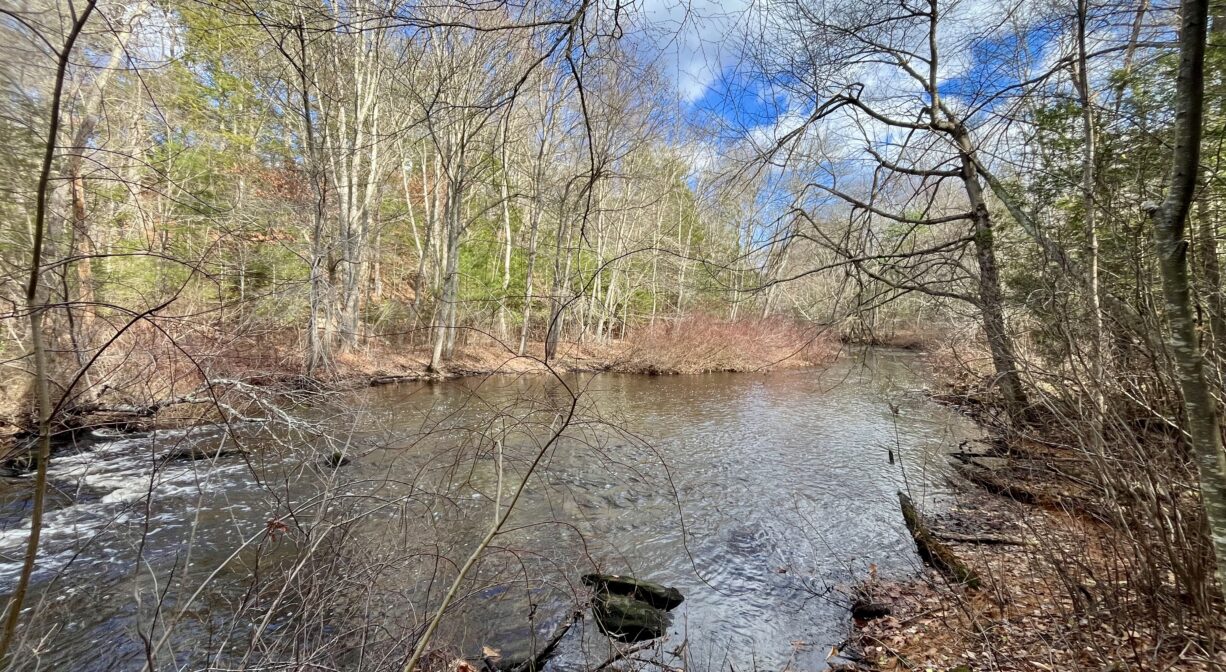
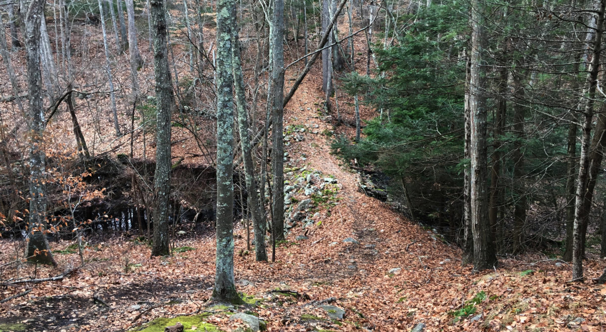
• If you are capable of navigating narrow, rocky trails with changing elevations, bear to the left. The trail snakes down the side of a hill. It can be slippery, especially when it is covered with fallen leaves. This leads to a a sometimes-damp trail that runs parallel to the shoreline of the Indian Head River, with some impressive glacial erratic boulders. At 0.27 miles, you will arrive at the mossy remains of an old stone dam that extends across the river. Very soon after, there is a steep trail to the right that climbs to the top of a cliff. Skip this for now and continue straight to visit a beautiful spot with tall rocky outcroppings on one side and the river on the other. By 0.34 miles, you will be at the river’s edge. Looking to the left, you can see where the old dam crosses the river and produces some rapids. From here, you can also see a large rocky outcropping on the Hanover side of the river. At 0.38 miles, you’ll see another old dam in the riverbed, and additional rapids.
At 0.41 miles, you will arrive at an intersection. Bear left to continue along the edge of the river. You’ll cross into Rocky Run Brook into the Tucker Preserve, where you can look for the historic Dwelly Rock and enjoy some spectacular scenery, along with views of the former Waterman Tack Factory and its broken industrial dam. Or bear right to complete the loop trail within Rocky Run. The trail heads uphill, past an old stone wall. Near the top of the hill, just after a red blaze on a tree, there is a captivating glacial erratic boulder that has been split into several parts. Continue up the hill. At about 0.52 miles, you’ll see a trail to the left with blue blazes. This short spur leads to another old stone dam — an impressively large one — that still permits some flow from Rocky Run Brook to pass through it. You might continue across the dam, down and up a hill, to follow this trail to the property boundary, but then be sure to return to the loop trail. Continue on the loop trail for another 0.1 mile or so to return to the first intersection. From there, it’s another 0.13 miles back to your starting place.
Habitats and Wildlife
Ancient forests were cleared in this area in the 1700s for farms, a forge and factory sites. Second-growth white pine forests have now grown up again as usage has shifted. There is also a beautiful grove of hemlock.
Rocky Run provides refuge for forest species typical to the South Shore. Otters, mink, and fisher cats like to be in or near water like the Indian Head River, where they can scavenge for food like herring and freshwater mussels. Animals like deer, opossums and coyotes make their homes in the rocky outcrops and crevices. Mass Wildlife stocks the river with brown and Eastern Brook trout.
Rocky Run Brook is a tributary to the Indian Head River. The Indian Head River rises from the Drinkwater River and Factory Pond in West Hanover. It forms the boundary between Hanover and Hanson, and merges with Pembroke’s Herring Brook, a short distance downstream of Ludden’s Ford Park, to form the North River at a spot called The Crotch. The North River flows 12 miles through Pembroke, Hanover, Norwell, Marshfield and Scituate, eventually making its way to Massachusetts Bay and the Atlantic Ocean.
FREE-FLOWING RIVERS are unaltered by human impact, and flow unobstructed, carrying and depositing nutrients and sediments along their corridors. They house essential native breeding grounds for migratory fish and provided for a biodiverse ecosystem. Prior to industrialized society, all rivers were free flowing, however, free-flowing rivers are now globally threatened, primarily by infrastructure. This section of the Indian Head River (IHR) flows freely. Native fish in the IHR that need free-flowing rivers to complete their life cycle include brook trout, brown trout, rainbow trout and northern redbelly dace.
There are two dams leftover from the industrial use of the river along the Indian Head River — the highly visible one at Ludden’s Ford, and the rock remnants of one just downstream of the State Street and Cross Street bridge in Hanson and Hanover. The dam at Ludden’s Ford Park is an obstruction for the thousands of river herring and shad that come each spring to spawn in the Indian Head River. There is a fish ladder on the dam, but it is difficult if not impossible to maintain, as it is in the middle of the spillway and it is likely impassable under certain conditions. The river is host to river herring, shad, eels, freshwater mussels, and native and stocked brook trout.
ROCKY OUTCROPPINGS: Rock outcroppings and enormous glacial erratic boulders border the trail at various points. You can walk or climb right up onto many of them! This also provides an excellent view of the river. There are a few sections of rapids along this section of the Indian Head too.
The outcrop of rock on both sides of the river is the top of a 12,000-foot-thick sedimentary rock unit that was formed during the Pennsylvanian Era (300 million years ago [MYA]). Named the Rhode Island Formation, it stretches across Southeastern Massachusetts and Rhode Island, from northeast to southwest. These sedimentary rocks are collectively included in what geologists call the Narragansett Basin. The Basin is approximately three miles wide at the mouth of the North River and fans out to about 22 miles wide in Bristol, Rhode Island.
Alternating layers of rock types can be seen of shale, sandstone and pebble conglomerate. The sedimentary environment for this deposit was a large, shallow, warm freshwater river system and associated lakes and swamps that filled with sediment and organic material.
During the Pennsylvanian Era, extensive shallow, freshwater wetlands across the globe where formed while global temperatures were several degrees warmer, resulting in the coal and oil deposits we use today. While difficult to find, several thin coal seams can be found on the other side of the river that contain fossilized ferns from the Pennsylvanian Era. During the 1970s energy crisis, several local universities studied the Basin for its potential coal reserves.
Originally deposited on top of older granitic rocks of the Precambrian Era (600 MYA), the Basin is now in contact with these granites at almost the same elevation; older granite can be found immediately to the north. This ancient border fault is now the North River/Indian Head River Valley Corridor. Remnants of this are seen here with what is called a “fault splay” off the main fault system. Looking at the outcrop, the original horizontal layers can be seen to be almost rolled and are cracked as a result of the faulting process. The steep drop in the rock to the south and the rapid rise in the rock on the other side of the river is the actual fault splay that the river now flows through.
A THREATENED FOUNDATION SPECIES: Within Rocky Run, there are a number of Eastern Hemlock trees, a threatened foundation species. The Eastern Hemlock can be found throughout the eastern United States, from Georgia to Nova Scotia, and west to Minnesota. It is now seriously threatened by the hemlock wooly adelgid (HWA), a nearly microscopic aphid-like insect that attacks the hemlock’s needles. The HWA begins its infestation on the lowermost branches and climbs to the crown of the hemlock over several years, stripping the tree of its needles., buds, and eventually, branches. Most hemlocks succumb to infestation within 5-10 years.
The hemlock wooly adelgid came to the US from Asia in the 1950’s, first arriving in Virginia. The sap-sucking insect then spread north over decades and has infected 90% of the eastern hemlock’s range. Eggs and nymphs can travel from location to location via birds and other wildlife, wind, humans, and the transportation of infected wood. The HWA deposits woolly egg sacs on hemlock needles. A sign of infestation, these sacs can be spotted from February through May. To identify hemlocks on your walk, look fora coniferous evergreen with dark brown scaly bark, flat green needles and small half-inch cones.
LIFE AMONG LICHEN: Look for lichen on the rocks and stone walls of the Rocky Run Conservation Area. Lichen is a pioneer species, and among the first to colonize a new environment in a process called “primary succession.” During primary succession, generations of pioneer species decay, enriching the soil and allowing more substantial and energy intensive plants to move in.
Lichen is a result of a symbiotic relationship between algae and fungi. Algae can photosynthesize and produce its own food, while fungi cannot. But fungi can break down organic matter and increase available nutrients in the soil. Algae and fungi work together to sustain their mutual existence; they flourish in nearly every ecosystem. In lichen, the algae produce sugars through photosynthesis, from which the fungi feed. In return, the fungi shelter the algae and prevent it from drying out, allowing the organism to live for hundreds, if not thousands, of years.
Lichen, like other photosynthesizing organisms, sequesters carbon and mitigates greenhouse gas emissions. It is, however, particularly sensitive to air pollution and in some cases, may die off or be replaced by a more pollution-tolerant species. Upon this discovery in the 1970s, the US Forest Service began using lichen to monitor air quality and pollution levels. Some types of lichen commonly found along the Indian Head River Trails include: Hypotrachyna sinus, Xanthoria polycarpa, and Chaenotheca furfuracea.


Historic Site: No
Park: No
Beach: No
Boat Launch: No
Lifeguards: No
Size: 19 acres
Hours: Dawn to Dusk
Parking: Limited on-site parking-site parking. Small lot immediately adjacent to the bridge over the Indian Head River on State Street at Hanover/Hanson town line.
Cost: Free
Trail Difficulty: Medium
Facilities:
Interpretive signage. Geocache location.
Dogs: Dogs must remain on leash. Always clean up after your dog!
Boat Ramp: No
ADA Access: No
Scenic Views: Yes
Waterbody/Watershed: Rocky Run Brook and Indian Head River (North River watershed)