
Owned By: Private
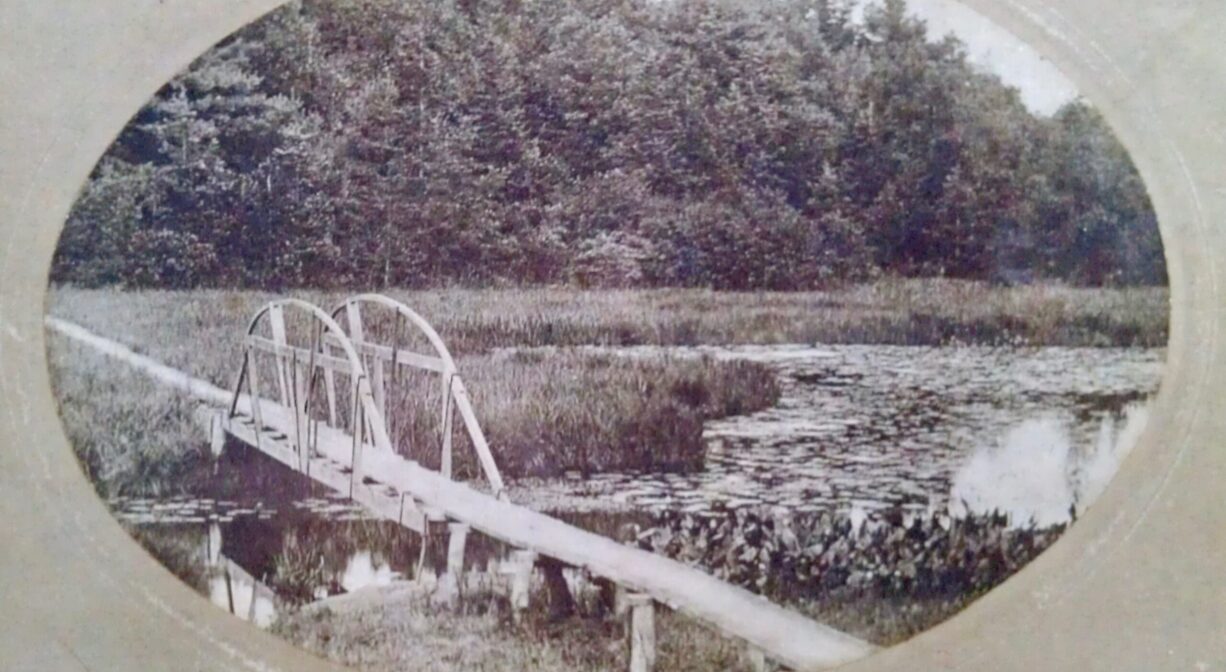
Rainbow Bridge, a footbridge between Hanover and Norwell, once stood at this spot on Third Herring Brook. Workers in the shipbuilding industry used it as a shortcut from the Hanover Yards to Fox Hill Shipyard. Named for its bowed shape, it has long since disappeared. This is a historical site only. There is no historic marker, and no public access from the land. But you can explore the lowermost portion of Third Herring Brook with a canoe, kayak or paddle board.
Features
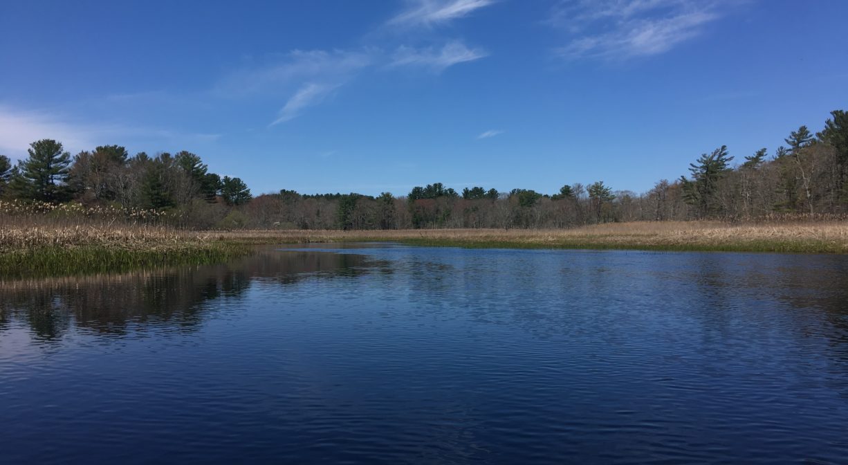
Third Herring Brook flows for about five miles and forms the boundary line between Hanover and Norwell before emptying into the North River. Its source is Valley Swamp, in Norwell, near the Hingham line.
Assinippi Brook, also known as Rocky Water Brook, flows into Third Herring Brook near Jacobs Pond. In 1829 there were quite a number of mills there — 3 grist mills, 3 sawmills, and a shingle mill, as well as a brick factory. Farther downstream, near the present-day Hanover YMCA, was a sawmill owned by John Clapp, and even farther downstream, T.J. Gardner’s saw and grist mills. Silver Brook, and Wildcat Brook are the next tributaries to Third Herring Brook. The stream then passes through Old Pond Swamp, the site of one of the first sawmills in the colony (1656), which was operated by Cornet Robert Stetson, Timothy Hatherly and Joseph Tilden.
Farther below is the former location of the Tolman Tack Factory (1837), as well as a box/shingle mill. Even farther downstream is the site of Tack Factory Pond (also known as Tiffany Pond). Charles Stockbridge erected a grist mill there in 1674, later owned by Jonah Stetson. Talbot and Salmond’s tack factory was erected there around 1830. It was eventually taken over by Edmund Sylvester. The old mill dam was removed in 2016 to encourage the return of herring to Third Herring Brook.
From there Third Herring Brook flows under River Street, where a log bridge was erected in 1660, later replaced by a bridge made of stone. The final tributary to Third Herring Brook is Copeland Tannery Brook. The Rainbow Bridge was located close to the mouth of Third Herring Brook, where it empties into the North River.
This land is within the region of the Massachusett (or Massachuseuk). To learn more about local Native American tribes, we encourage you to interact with their members. The Massachusett tribe at Ponkapoag and the Mattakeeset band of the Massachusett share information on their websites.
Trail Description
The best way to visit the site of Rainbow Bridge is on the water. For a short-but-sweet paddling excursion, put your boat in the water at the Pembroke Town Forest at ocean high tide or within 1-2 hours after. Paddle upstream, past Fox Hill Shipyard and then look for Third Herring Brook on the right. The bridge was situated near the spot where Third Herring Brook flows into the North River. You can continue on the water as far upstream as Historic Sylvester Field before turning back. After you return to the North River, you could paddle a little bit farther upstream to catch a glimpse of the historic Washington Street Bridge. Go close enough to see its bricks, but not close enough to pass underneath it. (Depending on the height and time of the tide, it can be tricky, if not impossible, to paddle against the current here.) Admire the historic bridge from a distance and then return downstream as the tide begins to recede. (2+ hours total)
Habitats and Wildlife
For centuries, herring have held important position in the web of life on the South Shore. They are a keystone species: birds such as heron and osprey, and other fish like striped bass and bluefish, rely on them for nourishment. Herring may not make up much of our diet now, but in Colonial days, and for centuries prior, residents of our area looked forward to the annual herring migration and the sustenance that came along with it. Back then, herring were abundant. In his 1634 book, New England’s Prospect, William Wood described alewives, a type of river herring, “in such multitudes as is almost incredible; pressing up in such shallow waters as will scarce permit them to swim.”
Industry on the South Shore began in the 17th century, first with small grist mills, and later with larger mills and factories. The same dams that created the water power to fuel these enterprises also prevented fish like herring from getting upstream. The result: a significant drop in the herring population. On many of our local streams, where once there were thousands of fish, now just a handful of herring return each spring.
For decades, NSRWA has been actively working to restore local herring runs. There were originally 4 dams on Third Herring Brook. So far, NSRWA has been able to collaborate with various partners to remove three of them. The first dam removal took place in 2014, at the YMCA’s Mill Pond. The next dam removal was in 2017 at Tack Factory Dam, farther downstream. A third dam removal took place in 2020 at the Hanover Mall. We have worked closely with numerous federal, state and local agencies, plus private landowners, to ensure the success of these projects.
The next phase of the project will be the installation of a fish ladder at Jacobs Pond (planned for 2025), with the ultimate goal of getting the fish back into the pond and to points farther upstream. The three completed dam removals have opened up 8.4 miles of stream for spawning fish! We are most eager to see their populations rebound. Even before the dams were removed, however, one could see hundreds of blueback herring as they returned just below where River Street and Broadway cross the brook, at the town line between Norwell and Hanover. There is a pull-off at this location where you can park and then carefully cross the street, to see the fish congregate before passing under the road. It is best to visit this site in May, as this is largely a blueback herring run.


Historic Site: Yes
Park: No
Beach: No
Boat Launch: No
Lifeguards: No
Hours: Dawn to Dusk
Parking: Water access only. No public parking.
Cost: Free
Dogs: No
Boat Ramp: No
ADA Access: No
Scenic Views: Yes
Waterbody/Watershed: Third Herring Brook (North River watershed)