
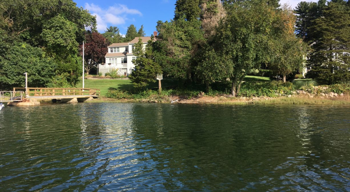
Owned By: Privately owned. No public access.
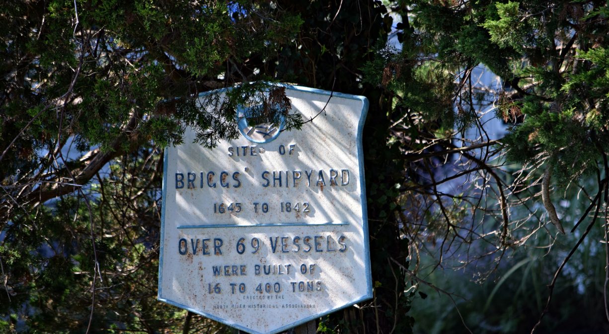
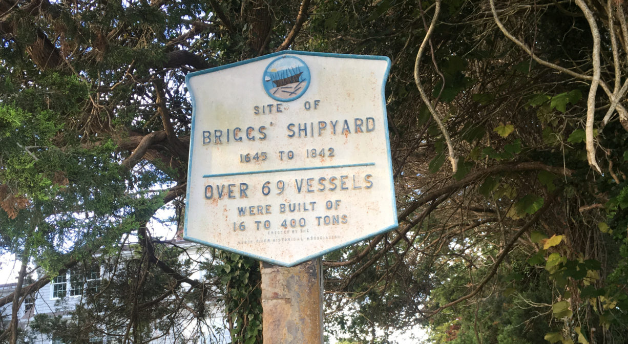
Briggs Yard and Hobart’s Landing is a historic shipyard site on the North River in Scituate. Shipyards were located here from 1645 to 1842, operated by various individuals and families. It is also known as Hobart’s Landing. The c. 1750 Briggs Shipyard produced the Columbia, the first American ship to circumnavigate the globe. A bronze plaque marks the spot. The property can be viewed from the river, but there is no public access.
Features
Thomas Nichols was the first to operate a shipyard here, around 1645. His daughter Rebecca married Samuel House Jr. in 1664. House continued the shipbuilding trade at this site, followed by Jeremiah and Walter Hatch. In 1676, Israel Hobart settled here (thus the name Hobart’s Landing) and worked as a shipbuilder for many years. The Briggs family began building ships at this site around 1750, beginning with James Briggs, and followed by Briggs men bearing the first names Cushing, Henry, William and Charles.
While other ships were very likely built before it on the North River, the first recorded ship — a brigantine named The Swallow — was constructed here in 1678.
According to Columbia’s River: The Voyages of Robert Gray, 1787-1793 by J. Richard Nokes, the Briggs yard claimed credit for construction of the Columbia, the first American ship to circumnavigate the globe. (According to L. Vernon Briggs’ History of Shipbuilding on North River, James Briggs built the original Columbia here at this shipyard, in 1773. )
Nokes states that construction took place “on the North River between Marshfield and Scituate,” and describes the Columbia as “square-rigged, with three masts, two decks, and the figurehead of a comely woman on the prow.” Nokes continues, “She bore the nameplate Columbia on her stern, and mounted ten cannon, six- and nine-pounders, plus numerous swivel guns… The heavy armament was to defend against commerce raiders of other nations, or against belligerent natives of lands to be explored.” The vessel likely weighed 212 tons, although some accounts have it as 220 or even 300 tons. Its length was 83.5′ with a beam of 23′.
Nokes further explains that in the summer of 1787, the sponsors of the ship Columbia had it “extensively rebuilt in Plymouth and fitted out by Dodd & Parkin at Long Wharf in Boston. They renamed her Columbia Redivida.”
The ship was owned by John Kendrick or Joseph Barrell. It’s captain, Robert Gray, was active in the gold and silver trade with China. However when he found that European traders were consistently outbidding him, he began instead to purchase fur in the Pacific Northwest. In 1792, he observed the Columbia River near what is now Portland, Oregon, and named it after his ship. The Columbia River became a major venue for the fur trade. The ship itself was decommissioned for salvage in 1806.
Our local shipbuilding industry sometimes employed slave labor, including an enslaved man named Jemmy, who worked at this yard. The cities of Boston and Newport were slave trading hubs, and some of the ships built on the North River were used in the slave trade. On a brighter note, a woman named Maria or Mariah, who was enslaved by the Briggs family beginning in 1673, later gained her freedom. In 1717, she and her husband, another formerly enslaved local named Tony Sisco, successfully sued the Briggs Family estate for the freedom of Maria’s daughter, Molly. Click here to learn more about this and other stories on the North River Early Black Heritage Trail.
The Hobart/Briggs Yard was also a packet landing — one of many on the North River. Packet ship lines were established prior to 1670, and thrived until railroads came to the South Shore in the mid-to-late 1800s. Over time, White’s Ferry, Little’s Bridge, Union Bridge, Hobart’s Landing, Foster’s Landing, Job’s Landing, Brick-Kiln Yard, and the North River Bridge in Hanover became regular stops. Farmers would meet the packet ship and barter their home-grown vegetables and dairy products for goods from China and Mediterranean, such as coffee, rum, sugar and spices. In addition to home-grown goods, packet pilots also bought wood, fish, pot iron, and charcoal from locals, and sold them lumber and ship supplies.
This land is within the region of the Massachusett (or Massachuseuk). To learn more about local Native American tribes, we encourage you to interact with their members. The Mattakeeset band of the Massachusett, and the Massachusett tribe at Ponkapoag, both share information on their websites.
Trail Description
No public access.
Habitats and Wildlife
There were 24 shipyards along the North River. Together they produced over 1,000 ships. All of those vessels were built with lumber culled from the surrounding forests. By the middle of the nineteenth century, few large trees remained. After the decline of the shipbuilding industry, the forests began to regenerate. Now, thanks in large part to conservation efforts, those forests have grown, providing essential wildlife habitat in the river corridor.
This property is located directly on the North River. The North River rises from marshes and springs in Weymouth, Rockland and Hanson. It is approximately 10 miles in length, with its source at the confluence of the Indian Head River (Hanover) and Herring Brook (Pembroke). From there it flows through the towns of Hanover, Pembroke, Marshfield, Norwell, and Scituate to the Atlantic Ocean between Third and Fourth Cliffs, draining approximately 59,000 acres along the way.
Historic Site: Yes
Park: No
Beach: No
Boat Launch: No
Lifeguards: No
Hours: Dawn to Dusk
Parking: Water views only. No public parking.
Cost: Free
Dogs: No
Boat Ramp: No
ADA Access: No
Scenic Views: Yes
Waterbody/Watershed: North River watershed