
1250 Ferry St, Marshfield, MA 02050, USA
Owned By: Town of Marshfield
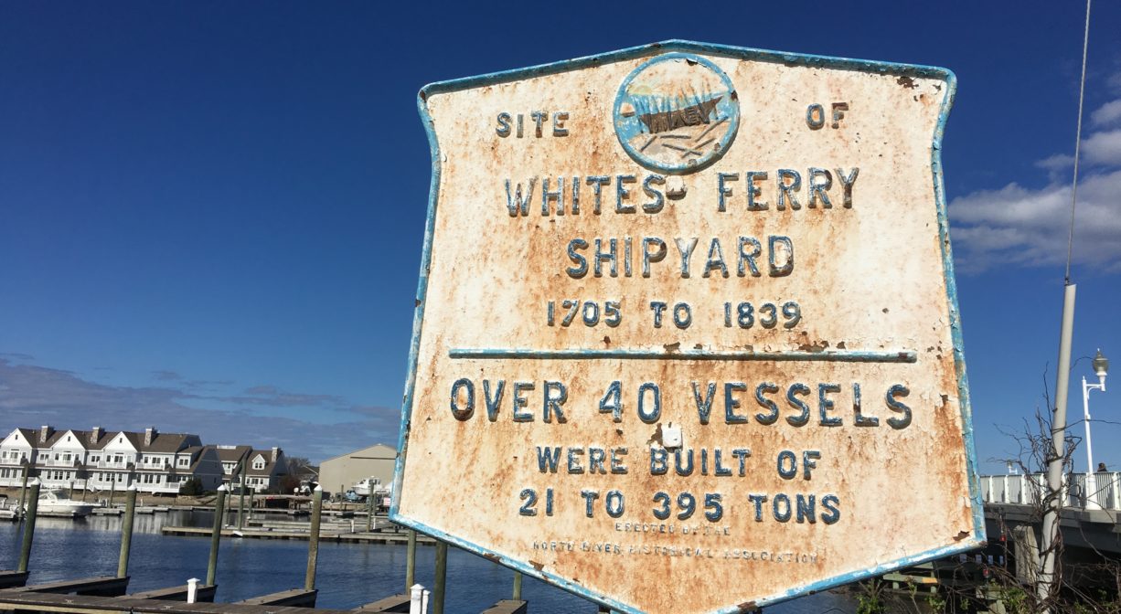
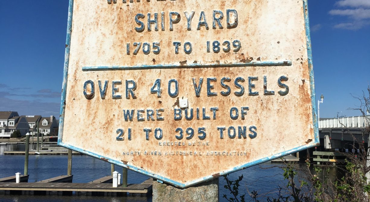
White’s Ferry is a historic spot on the South River, near Humarock. Look for the historic marker at the western end of the Sea Street Bridge, across the street from the Bridgewaye Inn. A ferry service operated here from 1638 to 1881 or 1882. Probably the oldest North River shipyards, including those of the Hall and Keene families, were located here as well. This was a prime location for shipbuilding, near the original river mouth. The 21-ton Mattakeesett, the only steamboat built on the river, was constructed at White’s Ferry in 1839. A plaque marks the site.
Features
In 1638, a ferry boat employed in transporting both men and cattle operated between Marshfield and Scituate here at the narrowest place in the North River (now the South River) — the location of today’s Sea Street Bridge. At the time, the location was known as New Harbor Marsh. Jonathan Brewster was the first ferryman. He was the son of Elder Brewster of Mayflower fame. He sold the ferry service in 1641 to Barker and Howell. Ralph Chapman later ran the ferry service, and then in 1712 Benjamin White, grandson of Peregrine White, took over.
There was a shipyard at White’s Ferry as early as 1705. The sloop Mary & Abigail (40 tons) was built that year. Simeon Keene built ships in 1787, beginning with the schooner Neptune (64 tons). Then from 1825-40 the Hall Family (mostly Luke, plus William and Samuel) built ships there. The only steamboat built on the North River was built there in 1839, the Mattakeesett (21 tons). The steamboat was intended to be put to use towing new vessels downriver, but this proved to be difficult because the winding course of the river did not permit an ample length of tow line. The Mattakeesett was sold and put to use in Boston Harbor instead.
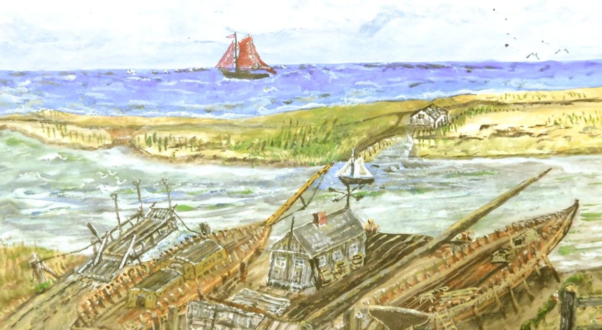
White’s Ferry Shipyard also produced spars, sails, cordage and rigging. Ships built upstream were often rigged here, and many also had their masts stepped, before setting out to sea. The painting featured here on the website is an artist’s rendering of White’s Ferry in shipyards days by W. Ray Freden. It is used with permission.
The local shipbuilding industry sometimes employed slave labor. Both Boston and Newport were slave trading hubs, and some of the ships built on the North River were use in the slave trade.
The ferry was replaced in 1881-1882 by the bridge from Marshfield to Humarock Beach. The bridge was constructed by The Fourth Cliff Land Company, to whom the town gave a quitclaim deed to “all the land or Hummocks below Fourth Cliff between the North River and the ocean to low water mark.” The bridge was built to service the resort hotel, Hotel Humarock. Over the bridge from Marshfield, it was on the right.
The bridge was replaced in 1952, and formally dedicated as the Captain Frederick Stanley Bridge in 1998, to mark the 100th Anniversary of the Portland Gale. (It was named in honor of the Captain of Humarock’s Lifesaving Station, 1880s-1910s.) The bridge was replaced again in 2007.
In the early days of Plymouth Colony, the Pilgrim Trail, also known as Green Harbor Path, was the main route from Plymouth to Scituate. From North Plymouth, it followed the coastline through Kingston, crossing the Jones River near Rocky Nook at a location known as the Wading Place. It continued through Duxbury along a route west of today’s Tremont Street/3A, and crossed into Marshfield at Careswell Street. Heading north through Marshfield, it crossed the Green Harbor River near today’s Bourne Park Ave. and crossed the South River at a spot called Valley Bars. From there it proceeded along the base of Snake Hill (Telegraph Hill) to White’s Ferry. After the ferry crossing at what was then the North River (now the South River), it proceeded along Humarock’s barrier beach, crossing into Scituate’s mainland between Fourth and Third Cliffs (the present location of the North River mouth). From there, it led to the Scituate First Church. This road was formally designated by Plymouth Colony in 1637. It was probably the first court-ordered road in America.
Packet ship lines were established prior to 1670, and thrived until railroads came to the South Shore in the mid-to-late 1800s. Over time, White’s Ferry, Little’s Bridge (Route 3A), Union Bridge, Hobart’s Landing, Foster’s Landing, Job’s Landing, Brick-Kiln Yard, and the North River Bridge in Hanover became regular stops. White’s Ferry was one of the most important landings. According to Joseph Foster Merritt, “much freight was left there.” Farmers would meet the packet ship and barter their home-grown products for goods from China and Mediterranean, such as coffee, sugar and spices. Packet pilots also bought wood, fish, pot iron, and charcoal from locals, and sold them lumber and ship supplies. A typical packet run, up and down the river, could take three or four days.
Trail Description
No trails, but the adjacent Sea Street Bridge is pedestrian-friendly.
Habitats and Wildlife
At this spot, the South River is a beautiful tidal estuary where wildlife abounds! Paddling or boating provides access for shellfishing, fishing or just exploring. Downstream there are salt marshes and numerous creeks, host to egrets and blue heron. You might even see a bald eagle!
There were 24 shipyards along the North River. Together they produced over 1,000 ships. All of those vessels were built with lumber culled from the surrounding forests. By the middle of the nineteenth century, few large trees remained. After the decline of the shipbuilding industry, the forests began to regenerate. Now, thanks in large part to conservation efforts, those forests have grown, providing essential wildlife habitat in the river corridor.
The South River originates deep in Duxbury. Its source is in the Round Pond area, and from there it winds unobtrusively through the woods for several miles. Although one can view it from Route 3, and also from both the South River Bog and the Camp Wing Conservation Area, it remains a narrow and mostly un-navigable stream until just below Veterans Memorial Park. From there it flows through South River Park, behind the playground of South River School, and under the Willow Street and Francis Keville Bridges. Wider at that point, and navigable at most tides, its course winds through the marshes as it runs parallel to Route 139, all the way to Rexhame. From there the river turns northward. It flows for 3 miles between Humarock and the mainland to Fourth Cliff, where it joins the North River at its outlet to the sea.


Historic Site: Yes
Park: No
Beach: No
Boat Launch: No
Lifeguards: No
Hours: Dawn to Dusk
Parking: Limited public parking on Sea Street and across the bridge on Marshfield Ave.
Cost: Free
Trail Difficulty: Easy
Facilities:
Historical marker. Geocache location.
Dogs: Dogs must remain on leash. Please clean up after your pet!
Boat Ramp: No
ADA Access: Yes
Scenic Views: Yes
Waterbody/Watershed: South River