
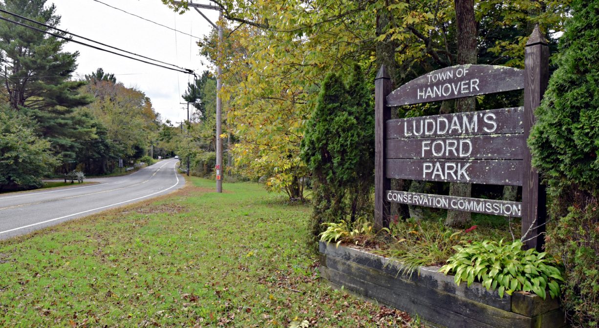
243 Elm St, Hanover, MA 02339, USA
Owned By: Town of Hanover
Ludden’s Ford Park is a 22-acre conservation property in Hanover, with open meadow and forested upland on the Indian Head River. It was known in the past as Luddam’s Ford Park. An industrial site for more than 200 years, it is now a beautiful park with a picnic/passive recreation area. The adjacent former railroad bed provides a 2-mile walk along the Indian Head with several captivating views of the river. Walk across the bridge on Elm Street to access the Pembroke portion of Ludden’s Ford Park. Look for a historic marker at the center of the bridge, which was completed in 1894.
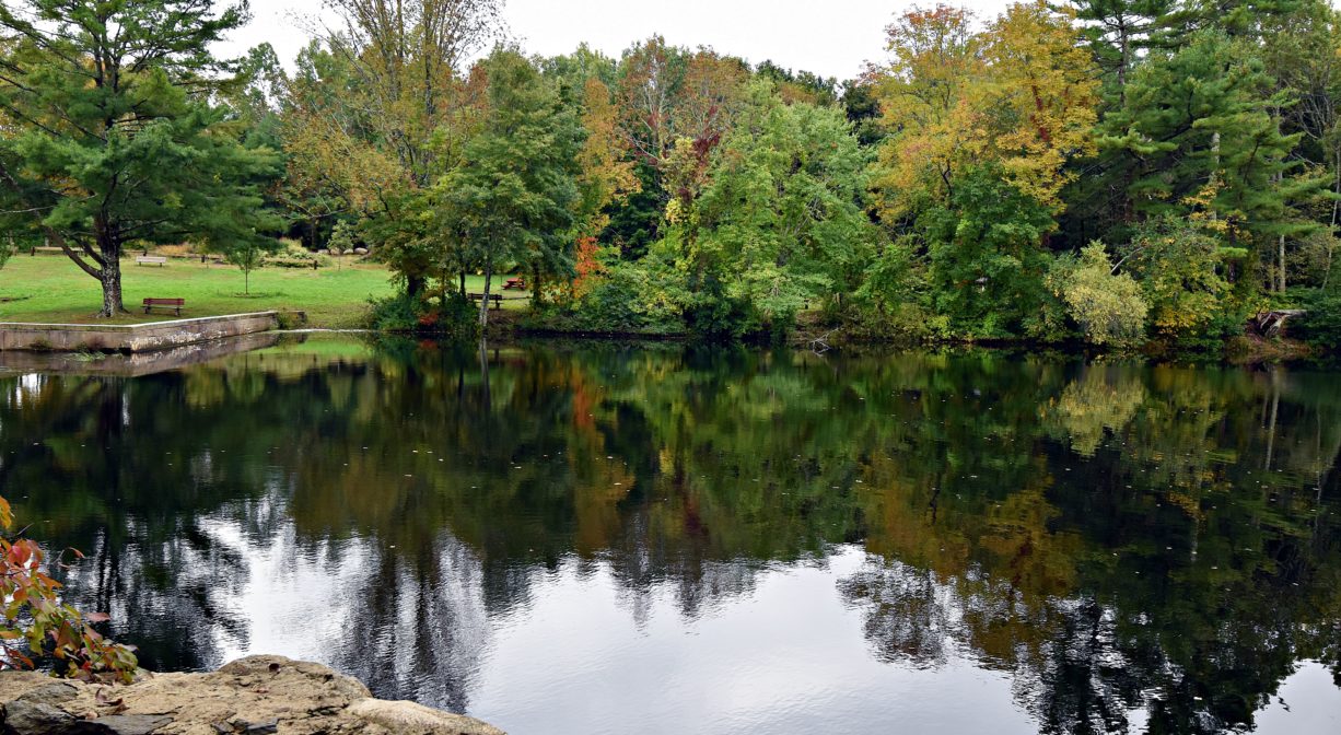
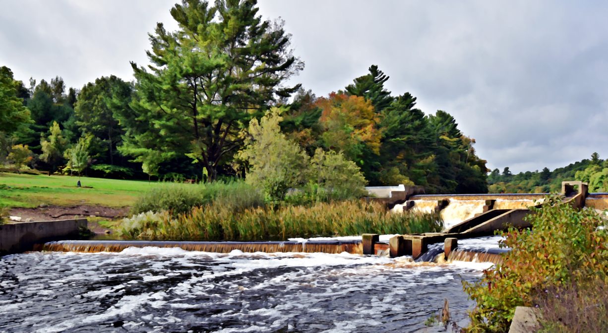
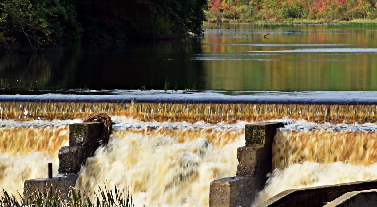
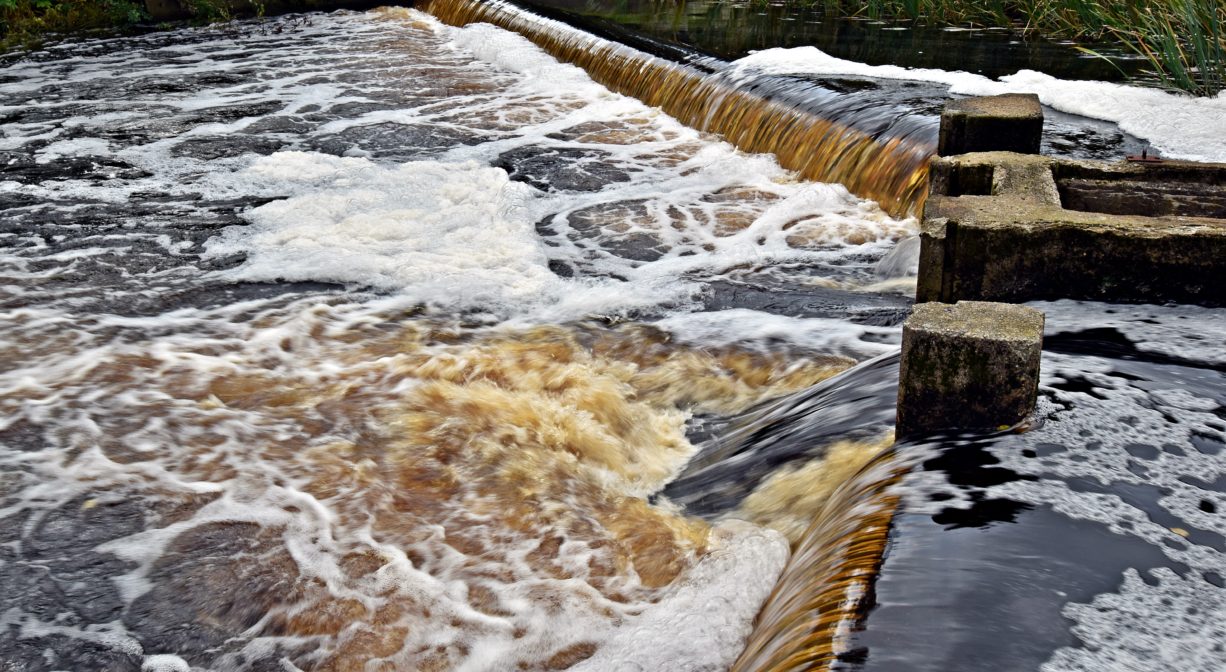
The Curtis Anchor Forge was located here in the 1700’s. Later the sprawling Clapp Rubber Mill was based here. Founded in 1873, it was the largest of its kind in the country. The dam on the Indian Head River fueled these industries as well as earlier mills. Now it forces migrating fish to scale a fish ladder as they swim upstream to spawn.
The impoundment (pond) created by the dam welcomes non-motorized boats and catch-and-release fishing. There are informal launch areas for canoe, kayaks and small boats on both sides of the river. Due to mercury contamination from 19th and 20th century industries upstream, fish caught here may not be consumed. When boating, be careful to stay away from the dam.
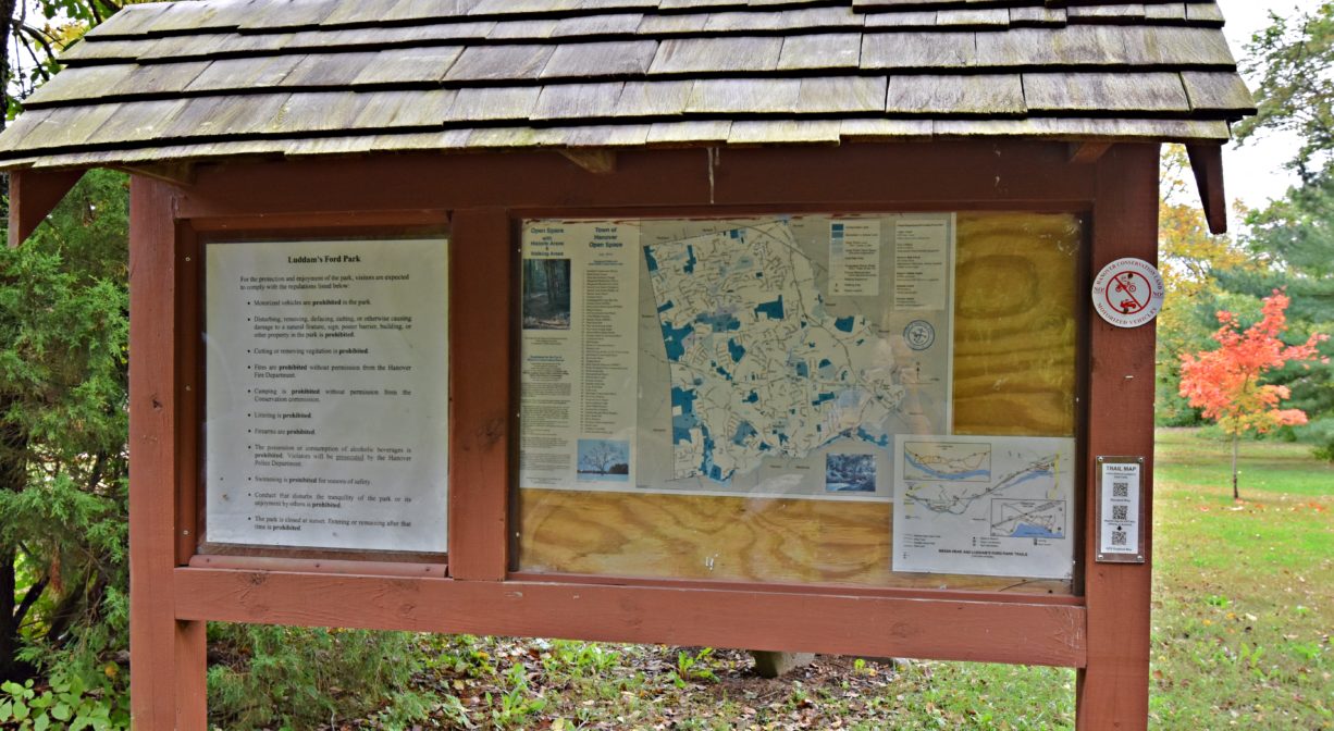
Hunting is not permitted on this property.
FISHING ADVISORY: It’s important to know that some of our freshwater fisheries are contaminated with mercury, PFAS and/or other concerning substances. The Massachusetts Department of Public Health maintains an online database with up-to-date advisories regarding fish consumption, sorted by location. We recommend you consult this valuable resource when planning a fishing excursion.
Features
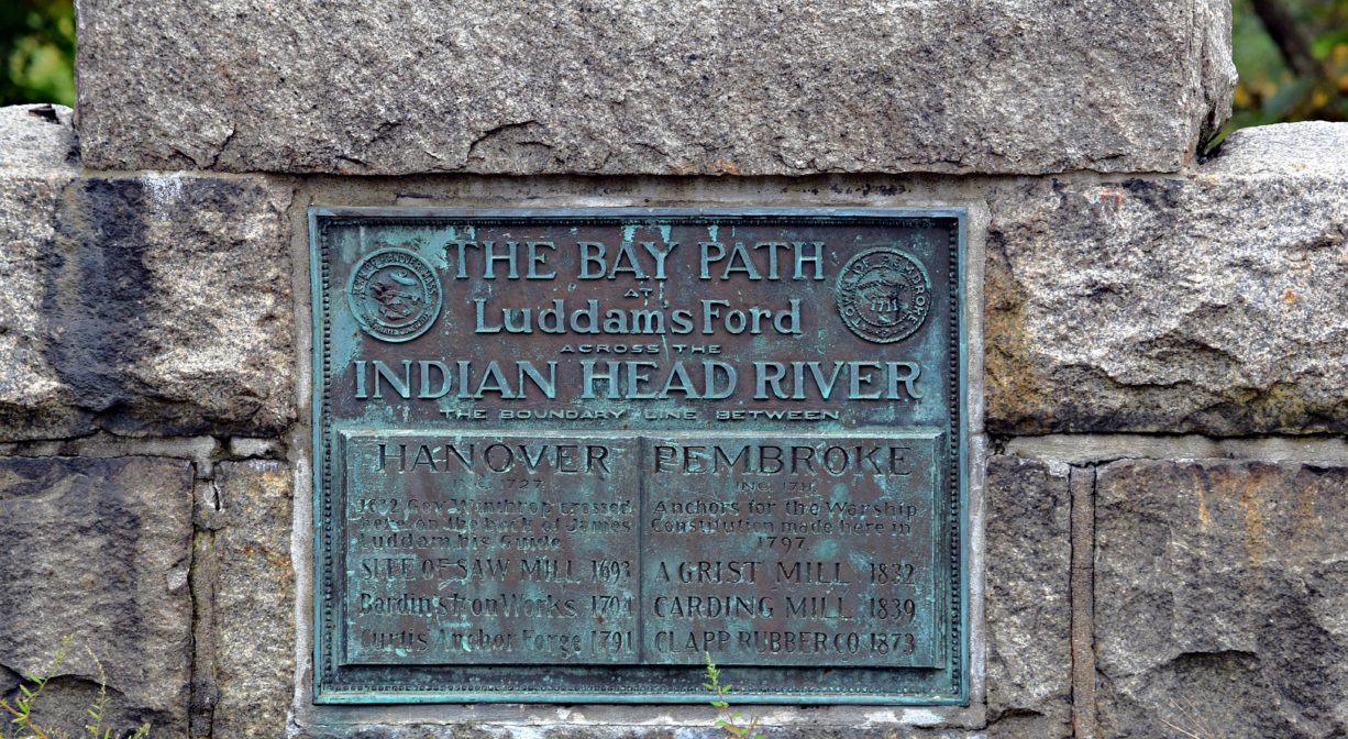
Ludden’s Ford (formerly known as Luddam’s Ford) is located on the historic Old Bay Path from Plymouth to Boston. It was named for James Ludden, the guide who in 1632 carried Governor John Winthrop of the Massachusetts Bay Colony across the river to visit Governor William Bradford of Plymouth Colony. Ludden was a settler, landowner and planter in the Wessagusset Colony at Weymouth.
In “Focus on History,” Hanover Historian Barbara Barker writes of an early dam here, c. 1693, established by Joseph Curtis, Josiah Palmer, and others, to power a sawmill. According to Hanover historians (Barry, Dwelley, Simmons), in 1704 Thomas Bardin built a dam just above Ludden’s Ford. He also erected an anchor forge, which supplied the shipyards below. Around the same time, a bridge was built here. It is said that Bardin was the first to produce bar iron in New England. His son continued the business.
1730 town records refer to “the old iron works,” which before 1740 was owned by the Josselyn family, who had trouble with the town because their dam prevented herring from swimming upstream to their spawning grounds. Subsequent owners of the iron works included Lemuel Dwelley, Benjamin Studley, and Lemuel Curtis. The company eventually was owned exclusively by the Curtis family, who continued to make anchors and do iron work for the shipyards downstream. The business employed 16 people and made 250 tons of anchors per year, each ranging in weight from 1000 – 10,000 lbs. A fire in 1848 destroyed the first iron works. It was rebuilt, and it flourished during the Civil War, making anchors for the US government, but ceased operations sometime before 1873.
There is some confusion around the question of whether or not the anchors for the USS Constitution were forged here. (The ship was launched in 1797). Joseph Grecco of Hanover has done extensive evidence-based research into the matter and has concluded that two of the USS Constitution’s 6 anchors were actually forged — not here — but a little farther upriver, at Barstow’s Forge, near the Hanson town line. (A historic sign currently marks the approximate location.)
Next at this site was the E. H. Clapp Rubber Works. In 1871, Eugene H. Clapp, a native of South Scituate (Norwell), invented a method for removing the fiber from old rubber and preparing it so it could be used again for new goods. He opened a reclaimed rubber manufacturing plant in Roxbury with two machines and two workers. In 1873 he moved the company to Hanover, where there were better water power facilities. He bought the George Curtis Anchor Works. Not having much capital, he and his cousin Fred Clapp made the minimum number of modifications to get the rubber mill up and running. Within a few days, the flumes were washed away by a flood, so they had to build new ones and also put in a new water wheel.
At first, water power was adequate to run the rubber works. It began with 2 grinding machines, but expanded quickly. Soon it could grind 1000 pounds a day. The mill was originally one story, but it increased to three. In 1879, steam power was added, which made the business grow so rapidly that the factory operated day and night. In 1881, the building was destroyed by fire, and then within a month’s time, rebuilt on a much larger scale, with the best equipment available.
In 1886 Clapp built another mill, on the Pembroke side of the river. By 1889, the mills employed 75-100 men – mostly locals — and could grind 20 tons per day. According to the Briggs History of Shipbuilding in 1889, “(Clapp) has now complete accommodation for handling and utilizing all kinds of rubber material according to the latest and best known processes, both mechanical and chemical, is doing two or three times as much work as any of his competitors, and is handling more than one half of this business in the United States.”
Today, Ludden’s Ford Park is serene and naturally beautiful. It is hard to imagine that only 150 years ago, the area was a booming industrial complex!
This land is within the region of the Massachusett (or Massachuseuk) Native American tribe. The Mattakeeset band of the Massachusett lived for thousands of years in the North River watershed. Their village included most of today’s Pembroke and Hanson. To learn more about local Native American tribes, we encourage you to interact with their members. The Massachusett tribe at Ponkapoag and the Mattakeeset band of the Massachusett share information on their websites.
Trail Description
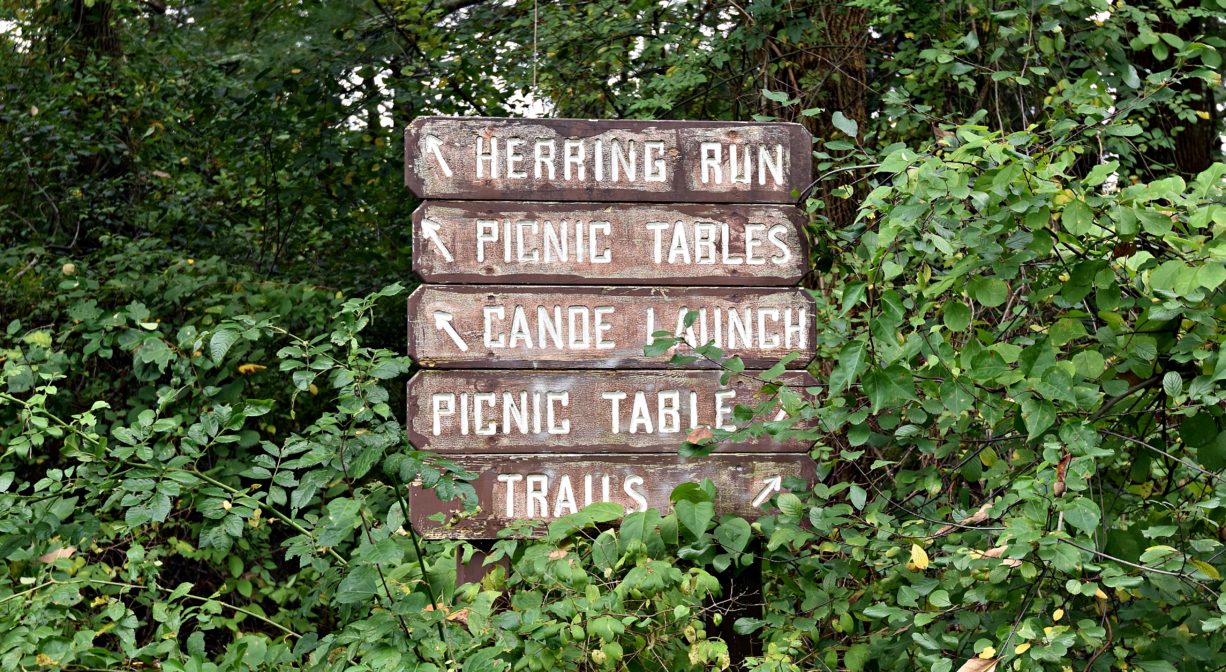
From the open recreation area, there are several access points to trails at Ludden’s Ford Park. One trail leads away from the river, to Water Street. Several other intersecting trails lead through the woods, between the river and the former railroad bed. The railroad bed itself is a trail that extends for two miles, to the Hanson town line, offering a number of pleasant vantage points.
Ambitious hikers could explore more than 4 miles of trail here. Setting off from Ludden’s Ford in Hanover, continue along the river and the old railroad bed for 2 miles (Indian Head River Trails), all the way to the Hanover/Hanson town line (you will have to walk on Water Street for one small section). Cross the Indian Head River on Cross Street/State Street, and look for the trailhead that takes you back into the woods. This will bring you through Hanson’s Rocky Run Conservation Area and along the river to the Tucker Preserve. Woodland trails follow the course of the river all the way to Ludden’s Ford Park in Pembroke.
Across the street from the Hanover section of Ludden’s Ford Park, look for the 0.26-mile Mattakeeset Trail, which extends parallel to Indian Head Drive, within view of the Indian Head River. It connects with the Hanover Public Launch, where you can continue your walk on the Chapman’s Landing and Iron Mine Brook Trails, immediately adjacent.
Habitats and Wildlife
The Indian Head River is freshwater and attracts many different species to its banks and surrounding forest. Mass Wildlife stocks the river with brown and Eastern Brook trout. Herring and shad can be seen at the base of the fish ladder in the spring. These fish attract mammals such as raccoons, striped skunks, coyotes, minks, muskrats, osprey, and fox. The meadow is excellent habitat for dragonflies.
The Indian Head River flows east through Ludden’s Ford Park and into the North River. It rises from the Drinkwater River and Factory Pond in West Hanover, and forms the boundary between Hanover and Hanson. It merges with Pembroke’s Herring Brook, a short distance downstream of Ludden’s Ford Park, to form the North River at a spot called The Crotch. The North River flows 12 miles through Pembroke, Hanover, Norwell, Marshfield and Scituate, eventually making its way to Massachusetts Bay and the Atlantic Ocean.
FISHING ADVISORY: The Indian Head River (IHR) has long been a popular fishing destination, and for good reason. The calm waters, miles of shoreline, and variety of fish make it an ideal location for the freshwater angler. Historically, this was a prime spot for herring, shad, smelt, bass, white and red perch, pickerel, brown bullhead, and even salmon. Due to mercury contamination from the National Fireworks site at Factory Pond in Hanover, the Massachusetts Department of Health has issued a health advisory that the general public should not eat any fish caught from Drinkwater River, Indian Head River or North River. While the source of the mercury contamination is located upstream, mercury bioaccumulates through the food chain, resulting in animals with increasingly higher concentrations of mercury in their bodies. Check current regulations prior to fishing in the IHR.
FISH MIGRATION: The fish ladder was constructed here with the intention of assisting migratory fish over the dam. Sadly, it is not very effective. Some fish do manage to get over it, though! In April and May, you can sometimes view herring here as they wait to enter the fish ladder. Look downstream of the dam at the right moment, and you might see thousands of fish. Unfortunately, due to the location of this fish ladder, in the middle of the spillway, we can’t figure a safe way to monitor or maintain the fish as they pass here. Thus we have no idea what their success rate might be, in getting past this dam. There is another dam — well, really just the rock remnants of a spillway — just below the State Street and Cross Street bridge in Hanson and Hanover.
We do know that the Indian Head River is a potential jewel in the crown of herring runs with restoration potential. We have been in discussion with the towns of Pembroke and Hanover about the feasibility of removing this dam. Stay tuned!
Diadromous fish spend one portion of their lives in saltwater and another portion in freshwater. These fish can be split into two categories: anadromous and catadromous. Anadromous fish spend the majority of their life in saltwater and return to freshwater to spawn. Catadromous fish spend the majority of their life in freshwater and return to saltwater to spawn.
Although anadromous and catadromous fish live opposite life cycles, they share the common need of freshwater rivers to survive. Unfortunately, habitat loss caused by dams and other human impacts like overfishing and pollution threaten the survival of these species. The protection of rivers like the Indian Head River is critical in providing safe breeding grounds and ensuring the continuation of the local species that rely on them.
Alewife – Alosa pseudopharengus: Also known as river herring, alewife are anadromous and are considered a keystone species. A variety of other fish, like striped bass, and wildlife prey on alewife to survive. Juvenile alewives consume algae, insect eggs and larvae, making them an important role in freshwater ecosystems. Due to dwindling populations, it is prohibited to harvest alewife both recreationally and commercially in Massachusetts.
American Eel – Anguilla rostrata: Despite their slender snake-like appearance, American eels are true fish with scales. The American eel is the only catadromous fish in North America and when mature, migrates out to the Sargasso Sea near Bermuda to spawn and then die. Like other fish species that rely on freshwater rivers for survival, the fragmentation of rivers due to dams, overfishing, water withdrawals and pollution continue to threaten eel populations.
Blueback Herring – Alosa aestivalis: Blueback herring, named for the visible bluish coloration near its dorsal fin, can be found along the Atlantic coast from Nova Scotia to Florida. Like the alewife, blueback herring are anadromous and both of these river herring are keystone species and are vital to the aquatic ecosystem. Predators such as ospreys, herons, striped bass and seals rely on blueback herring to survive and without this fish, the food chain would be severely disrupted.
American Shad – Alosa sapidissima: The American shad is native to the east coast of the United States and Canada and are anadromous. A Federal Trust fish, the American shad is protected under the United States Anadromous Fish Conservation Act. This legislation supports the improvement and revitalization of fish habitat through conservation and research efforts. Known for its edibility, the American shad’s populations, like the river herring, have been negatively affected by dams and other forms of human impact.


Historic Site: No
Park: Yes
Beach: No
Boat Launch: Yes
Lifeguards: No
Size: 22 acres
Hours: Dawn to Dusk
Parking: Limited on-site parking at 243 Elm Street, Hanover.
Cost: Free
Trail Difficulty: Easy
Facilities:
Benches, canoe/kayak launch, fish ladder, several picnic tables, trash receptacles, interpretive signage.
Dogs: Dogs must remain on leash. Please clean up after your pet!
Boat Ramp: No
ADA Access: No
Scenic Views: Yes
Waterbody/Watershed: Indian Head River (North River watershed)