
1295 Main St, Marshfield, MA 02050, USA
Marshfield Conservation: (781) 834-5573
Owned By: Town of Marshfield
Furnace Brook Watershed Conservation Area is a 257-acre property in Marshfield that protects five town well sites. Furnace Brook, the South River’s largest tributary, flows through the long, narrow parcel from north to south. There is a 2-mile network of trails in the northern section, between Pine and School Streets, and a 1.3-mile loop trail in the southern section, between School and Furnace Streets. In addition to being a public walking trail, the southern loop is where the Marshfield High School Cross Country team practices and sometimes competes.
Hunting is not allowed at Furnace Brook Watershed Conservation Area, or at any of Marshfield’s other conservation properties.
Features
The Furnace Brook Watershed was the Town of Marshfield’s first major conservation land acquisition. Efforts began in 1971 and culminated with the purchase of 224 acres in 1973. This involved separate negotiations with 40 different land owners! The property contains old stone walls that provide evidence of its agricultural past. The brook itself was known as Puddle Wharf Brook in earlier times.
Furnace Brook was home to industry, especially in the 1800s, but it took place downstream of this conservation area. From about 1838-1868, the Bonney family operated an iron furnace on Furnace Pond, making use of natural bog iron ore deposits nearby. It’s likely that this furnace gave the brook its name. Farther downstream, near today’s Parsons Pond, Jesse Reed operated an elaborate nail manufacturing complex, which included a factory, a forge, a water wheel and a canal system.
This land is within the region of the Massachusett (or Massachuseuk). To learn more about local Native American tribes, we encourage you to interact with their members. The Mattakeeset band of the Massachusett, and the Massachusett tribe at Ponkapoag, both share information on their websites.
Trail Description
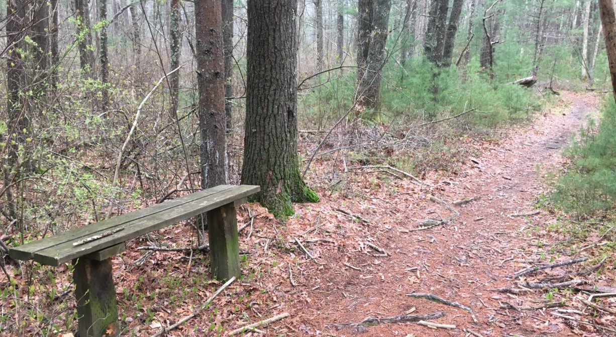
Trailheads are located on School, Pine, Forest, Furnace, and Main Streets. Parking is not permitted at the School Street Pump Station. Carrying a map is strongly advised. There are large loops on both the north and south sides of the property, with spur trails leading to each of the trailheads, as well as to Furnace Brook. Some sections of the trail are wide, flat and sandy; others are steep, rocky and rooty.
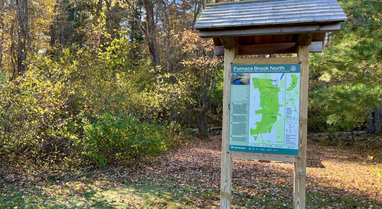
• The 1-mile northern loop (red and blue) is most easily accessed via the parking area at St. Christine’s Parish on Main Street (Route 3A). Look for the kiosk at the trailhead. A bridge was installed in 2023. The trails marked in red are relatively easygoing, and extend for over a mile, all the way to School Street with a few short stretches of boardwalk. Along the way there are two moderate hills and some sections that can be wet/slippery. The trails marked in blue and yellow are steeper and more hilly, often with rocks and roots. There is a second, even hillier 1-mile loop on the blue and white trails in the northwestern corner of this part of the property, approaching the intersection of Pine and Forest Streets. The 300-foot Meditation Loop, marked in gold, leads up a gentle slope with some roots and rocks to step over.
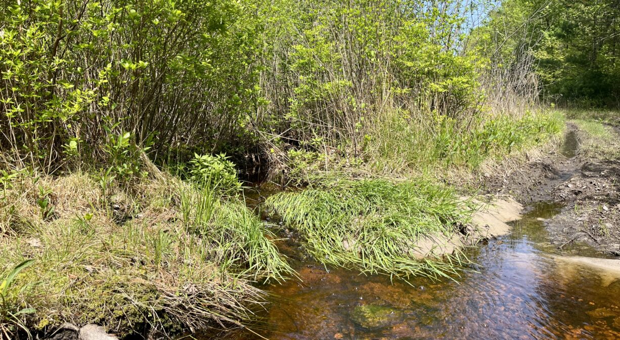
• The 1.3-mile southern loop — between School, Forest, Furnace, and Main Streets — is best accessed from Forest Street. Look for the Marshfield Cross Country sign across from the entrance to the high school complex, and then continue a short distance north. You’ll soon find an unmarked semi-paved road to the right. Several spur trails lead to the loop itself. The trail encircles a large sand & gravel pit in a fairly uniform oval, and runs alongside Furnace Brook for a short distance. It is marked with occasional white/green arrows. There are additional spur trails off the loop that lead to School Street, Old Main Street, Furnace Street, and private homes off Forest Street. There are also two spur trails that lead directly to additional views of Furnace Brook itself. This 2025 video, featuring Ned Bangs, Chair of the Marshfield Trails Committee, offers a tour of this side of the property.
• The spur trail that extends from the southern loop heading north to School Street is a great way to access the northern loop. After crossing School Street, continue on the trail, passing through a power easement (where you can view Furnace Brook again) and into the woods. The 1-mile loop trail on this side of the property is a much more hilly and circuitous than the southern loop.
• For a quick visit to Furnace Brook itself, look for the small parking area on Furnace Street. Follow the semi-paved road into the property and look for the trail that leads off to the left, running more-or-less parallel to Furnace Street. After about 0.1 mile, you will arrive at an old bridge where you can view the brook. You can also view the brook at the bridge just inside the Main Street entrance, and from the power easement along the spur trail that extends from the northern loop to School Street.
Habitats and Wildlife
Furnace Brook finds its source in springs north of Pine Street. It flows south along the base of Carolina Hill, through Furnace Pond and Parsons Pond, and eventually into the South River at a tiny conservation property known as South River Junctions, just upstream of Veterans Memorial Park. Much of the land surrounding the brook is protected, either for conservation or water protection.
The Furnace Brook Watershed Conservation Area contains numerous white pine trees. Dotted among the pines are the occasional oak, holly, maple, cedar, hickory, black walnut, cherry and yellow birch. In the southern section, around the sand & gravel pit, there’s also some pitch pine. Shrubs such as blueberry, raspberry, viburnum, and swamp azalea are also common, as are ferns and sweet pepper bush. Most of this property is damp, so there’s also a lot of moss. Watch for the occasional outcropping of granite — or even quartz!
The South River originates deep in Duxbury. Its source is in the Round Pond area, and from there it winds unobtrusively through the woods for several miles. Although one can view it from Route 3, and also from both the South River Bog and the Camp Wing Conservation Area, it remains a narrow and mostly un-navigable stream until just below Veterans Memorial Park. From there it flows through South River Park, behind the playground of South River School, and under the Willow Street and Francis Keville Bridges. Wider at that point, and navigable at most tides, its course winds through the marshes as it runs parallel to Route 139, all the way to Rexhame. From there the river turns northward. It flows for 3 miles between Humarock and the mainland to Fourth Cliff, where it joins the North River at its outlet to the sea.


Historic Site: No
Park: No
Beach: No
Boat Launch: No
Lifeguards: No
Size: 287 acres
Hours: Dawn to Dusk
Parking: Park at the trailhead at St. Christine's Parish, 1295 Main Street (Route 3A) or in the large informal parking area on Forest Street, across from Flames Road. Additional pedestrian access from School, Pine, Forest, and Furnace Streets. Small parking area with minimal trail access on Furnace Street.
Cost: Free
Trail Difficulty: Easy, Medium
Facilities:
One bench, one picnic table, informational kiosk, footbridges. Geocache location.
Dogs: Dogs must remain on leash. Always clean up after your dog!
Boat Ramp: No
ADA Access: No
Scenic Views: Yes
Waterbody/Watershed: Furnace Brook (South River watershed)