
24 Marshfield Ave, Humarock, MA 02047, USA
Town of Scituate: (781) 545-8700
https://www.scituatema.gov/1751/Beach-Sticker-Wheelchair-Information
Owned By: Town of Scituate
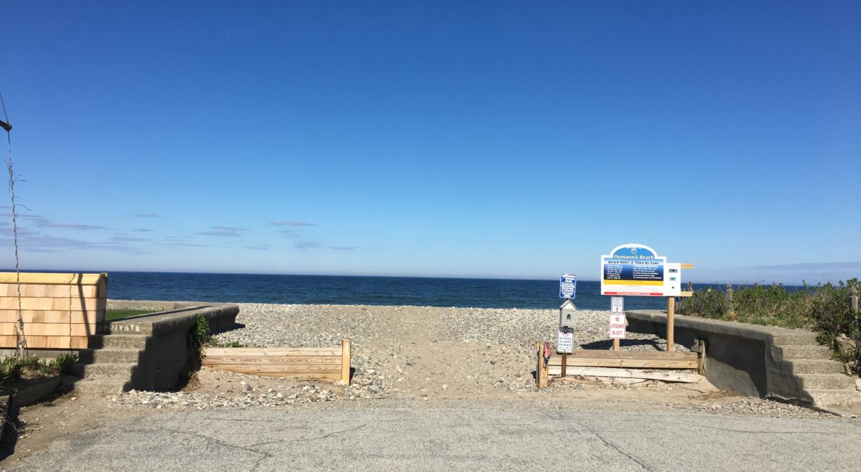
Humarock Beach is one of Scituate’s public beaches, but it is only accessible through Marshfield. On one side is the Atlantic Ocean, and on the other side is the South River. There is a launch ramp in the town parking lot, but it requires a 250-foot portage over sand and cobble. The parking lot also features a basketball court. There is no charge for off-season parking. In addition, there is limited on-street parking nearby. For more information, visit the Town’s website.
FISHING ADVISORY: It’s important to know that some of our freshwater fisheries are contaminated with mercury, PFAS and/or other concerning substances. The Massachusetts Department of Public Health maintains an online database with up-to-date advisories regarding fish consumption, sorted by location. We recommend you consult this valuable resource when planning a fishing excursion.
SWIMMING: Massachusetts routinely checks water quality at public swim spots and shares the data in an online database. Save this link so you can check water quality before you go.
Features
Each year, Scituate sells a limited number of non-resident beach stickers, for Humarock, and for “all access.” For more information, call (781) 545-8718, or visit the town website.
A common belief is that the name “Humarock” derives from “Humming Rocks” (referring to the crash of the surf). However historical records suggest that the origin of the name lies in the word “hummock,” i.e. a hill near a marsh. As early as 1732, town records refer to the Fourth Cliff area as “Hummock Flats” and other variants. An 1879 Scituate town map labels the peninsula south of Fourth Cliff as “Shore Hummock.” The shoreline of Humarock is characterized by the presence of innumerable roughly fist-sized, smooth, flattened rocks and these were even more prevalent before the Blizzard of ’78. The name “Hummock Rock-beach” became “Humarock Beach” and finally “Humarock”.
Humarock is a narrow peninsula, about 3 miles long. Have you ever wondered why it is part of Scituate, not Marshfield? It’s not attached by land to Scituate. It’s actually contiguous with Marshfield – by land, via the Rexhame Dunes. (It’s also attached to Marshfield by two bridges, on Sea Street, and on Julian Street.)
Before 1898, the mouth of the North River was located at the southern end of Humarock, near present-day Rexhame Beach in Marshfield. The site of the current mouth between Third and Fourth Cliffs was then a narrow barrier beach. On November 26 and 27, 1898, a Nor’easter known as the Portland Gale struck the New England coastline. It is remembered particularly for wreaking havoc on the South Shore and Cape Cod. Named after one of over 100 ships that were wrecked during the course of the storm, the Portland Gale claimed more than 400 lives in under 24 hours. It is considered to be New England’s worst maritime disaster, with widespread destruction of homes, railroad tracks, and bridges.
At the height of storm, a surge on the river washed right over the beach between Humarock’s Third and Fourth Cliffs, and out to sea. It was powerful enough to make a permanent cut in the beach. After that, the outgoing river tides continued to flow through what became known as New Inlet to the sea, and the incoming ocean tide flowed through to the river. Thus, the North River, with its mouth now 3 miles farther north, became 3 miles shorter! And the South River – which originally flowed into the North River at Rexhame – became 3 miles longer. After a couple of years, the old mouth at Rexhame soon filled in with sand and became part of the beach. It’s now the northern portion of the Rexhame Dunes.
In the years since the Portland Gale cut a new inlet for the North River, the size of the mouth has increased fifteen times over. What was once only 200 feet wide and ten feet deep is now 1/2 to 1 mile wide and up to 60 feet deep. The Rexhame Dunes now stand at the site of the old mouth. The dunes rise at least 20 feet above the mean high tide level, helping to enclose one of the more unique landscapes on the South Shore.
As early as 1636, the section of the river to the west of Fourth Cliff was known as New Harbor. Vessels wintered in the lee of Fourth Cliff in an area called Pincin’s Bank. There was a Colonial settlement and ferry south of New Harbor. The ferry was established in 1638, kept by Jonathan Brewster, son of Elder Brewster. It passed through several hands until 1712 when the title passed to Benjamin White, grandson of Peregrine. Since then it has been known as White’s Ferry.
There was a shipyard at White’s Ferry as early as 1705. Simeon Keene built ships in 1787, beginning with the schooner Neptune. Then from 1825-40 the Hall Family (mostly Luke, plus William and Samuel) built ships there. The only steamboat built on the North River was built there in 1839, the Mattakeesett (21 tons).
The ferry was replaced in 18881 or 1882 by the bridge from Marshfield to Humarock Beach. The bridge was constructed by The Fourth Cliff Land Company, to whom the town gave a quitclaim deed to “all the land or Hummocks below Fourth Cliff between the North River and the ocean to low water mark.” The bridge was built to service the resort hotel, Hotel Humarock. Over the bridge from Marshfield, it was on the right. Stables were across the street. Prior to this time, Humarock itself was largely undeveloped, and used primarily for farming — raising crops and cattle, and harvesting salt marsh hay.
The extensive marsh system behind Fourth Cliff – like many marsh areas at the time — was considered very valuable both for hunting and salt hay. Many families kept tiny hunting/gunning shanties. You can view the remains of the Hatch Gunning Stand from the water. The Tilden family of Scituate had a succession of houses on Fourth Cliff, the last of which was built in 1828. There was also a single boarding house for summer visitors, The Fourth Cliff House, constructed in the mid-1800s, burned down in 1902.
The Fourth Cliff Lifesaving Station (part of The Humane Society, which later became The Coast Guard) was located in a remote spot on the south side of Fourth Cliff, just under the big bluff. It was built in 1879 and burned down in 1915 or 1919. The Lifesaving Station had a crew of 7 men and a 25-foot lifeboat. Fred Stanley was the station keeper. The northern patrol route was across the gravel road on the shingle beach, all the way up to First Cliff, along the water. The southern route was to the mouth of the river, about 3 miles, near present-day Rexhame Beach. It was not rebuilt, because by 1915/1919 the Coast Guard was using different boats and different ports.
Hotel Humarock was one of the largest hotels in Scituate at the turn of the 20th century. It accommodated 250 guests. It had gas-powered lights, electric bells in every room, spring water, “cuisine,” and a telephone. Also bowling (there were 3 alleys in a separate building) and a billiards hall. Also advertised as “30 miles from Boston and 1 mile from the Seaview railroad station over a good road with beautiful country scenery.”
An advertisement read: “The Hotel Humarock at Humarock Beach is delightfully situated, fronting the ocean. It stands right at the water’s edge on a smooth sandy beach, which stretches away for miles in a graceful curve. From its broad and sandy piazzas, one may snuff the cool salt air, while the eye is rested by the swell of ocean waves. Landward and across the North River the pretty hills of Marshfield are in view, giving a combination of seaside and mountain resort rarely met.” Cost = $2.50-$3/day.
The Hotel Humarock burned down in June 1901. By then the Fourth Cliff Land Company had broken up, and thus individual lots were being sold and built upon. Sea walls were probably built around 1923. By the 1930s, on Marshfield Ave. there was Covell’s gas station on the site of the Hotel Humarock stables, the Atlantic & Pacific Tea Company across Central Ave. from what is today Humming Rock Gifts, and Clark’s General Store across the street from that. (The general store was Hotel Royal in 1911, and Sands End Café recently, now The Voyage.) Daniel Webster Clark was one of the best-known residents of Humarock. He was born in Vermont and came to Scituate in the early 1930s. As a real estate developer, he saw the possibilities of Humarock and almost single handedly transformed the area into one of the best-known resorts on the South Shore. He was also postmaster for the last 17 years of his life, 1913-1930.
According to Fred Freitas’s book Humarock: Hummocks, Humming Rocks, and Silver Sands, the widespread construction of cottages on Humarock began in 1940, when the Silver Sands development (ultimately 145 houses) was established on Fourth Cliff. Shortly thereafter, the New Humarock Beach development commenced, stretching south for 3 miles, adding a few hundred more, plus new roads and utilities. However, much of Silver Sands was soon taken by the government, in order to establish the Fourth Cliff Military Reservation (now the US Air Force Recreation Area).
The Sea Street Bridge was fortified during WWII to sustain heavy equipment going to the military base on Fourth Cliff, and then rebuilt entirely – still as a wooden structure — in 1952. It was rebuilt again from 2007-2008, but this time it was an eight-span pre-cast concrete structure, and at the same time, the channel underneath was widened and deepened to facilitate boat traffic.
This land is within the region of the Massachusett (or Massachuseuk). To learn more about local Native American tribes, we encourage you to interact with their members. The Mattakeeset band of the Massachusett, and the Massachusett tribe at Ponkapoag, both share information on their websites.
Trail Description
No trails, but the 3-mile long beach offers ample terrain for walking. Head north and you can go all the way to Fourth Cliff, where there’s a view of the river mouth. Head south and you’ll eventually cross the town line into Marshfield at Rexhame Beach.
Habitats and Wildlife
Humarock Beach is located on a 3-mile long barrier beach, between the Atlantic Ocean and the South River. Like the North River, the South River is a beautiful tidal estuary where wildlife abounds! Paddling or boating on this estuary allows you to go shellfishing, fishing or just exploring. Downstream there are salt marshes and numerous creeks, host to egrets and blue heron. You might even see a bald eagle!


Historic Site: No
Park: No
Beach: Yes
Boat Launch: Yes
Lifeguards: Yes
Hours: Dawn to Dusk
Parking: For the large paved parking lot, a Scituate beach sticker is required Memorial Day weekend through Labor Day. No fee for off-season parking. There are also several public parking spaces on Marshfield Ave.
Cost: Free
Trail Difficulty: Easy
Facilities:
Porta potties, in season. If you don’t mind a 250-foot portage over sand and cobble, from the parking lot, you can launch a canoe or kayak on the South River. Basketball court in parking lot.
Dogs: Yes, in the off season. From June 15 to September 15, dogs are not permitted on any town beach between the hours of 10am and 6pm. Always clean up after your dog!
Boat Ramp: No
ADA Access: No
Scenic Views: Yes
Waterbody/Watershed: Massachusetts Bay, South River