
325 Standish St, Marshfield, MA 02050, USA
781-831-1563, 781-536-2500 x. 294
https://www.marshfield-ma.gov/services/marshfield_beaches/index.php
Owned By: Town of Marshfield
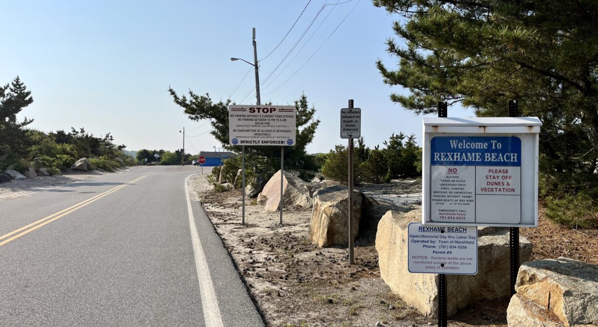
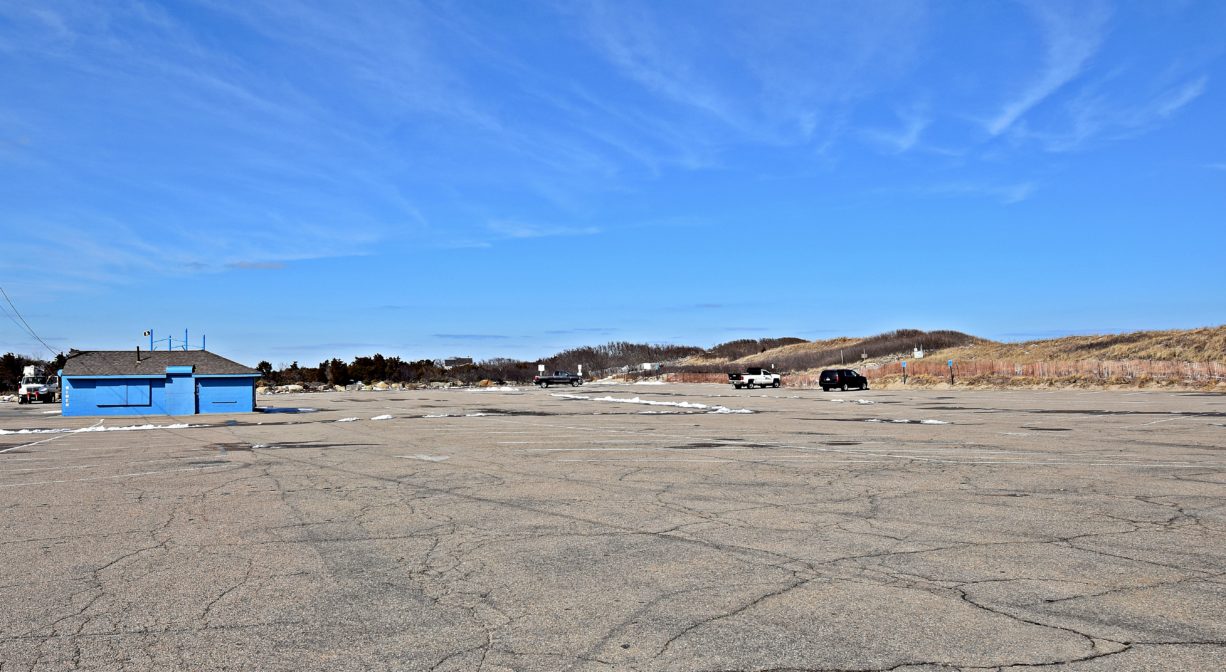
Rexhame Beach is a town-owned public beach in Marshfield, situated between the Atlantic Ocean and the South River. In season, it offers a snack bar, lifeguards, and restrooms. There is also a small fenced-in toddler playground. It is located at the end of Standish Street, with resident and non-resident parking.
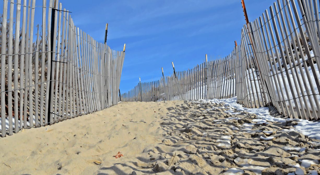
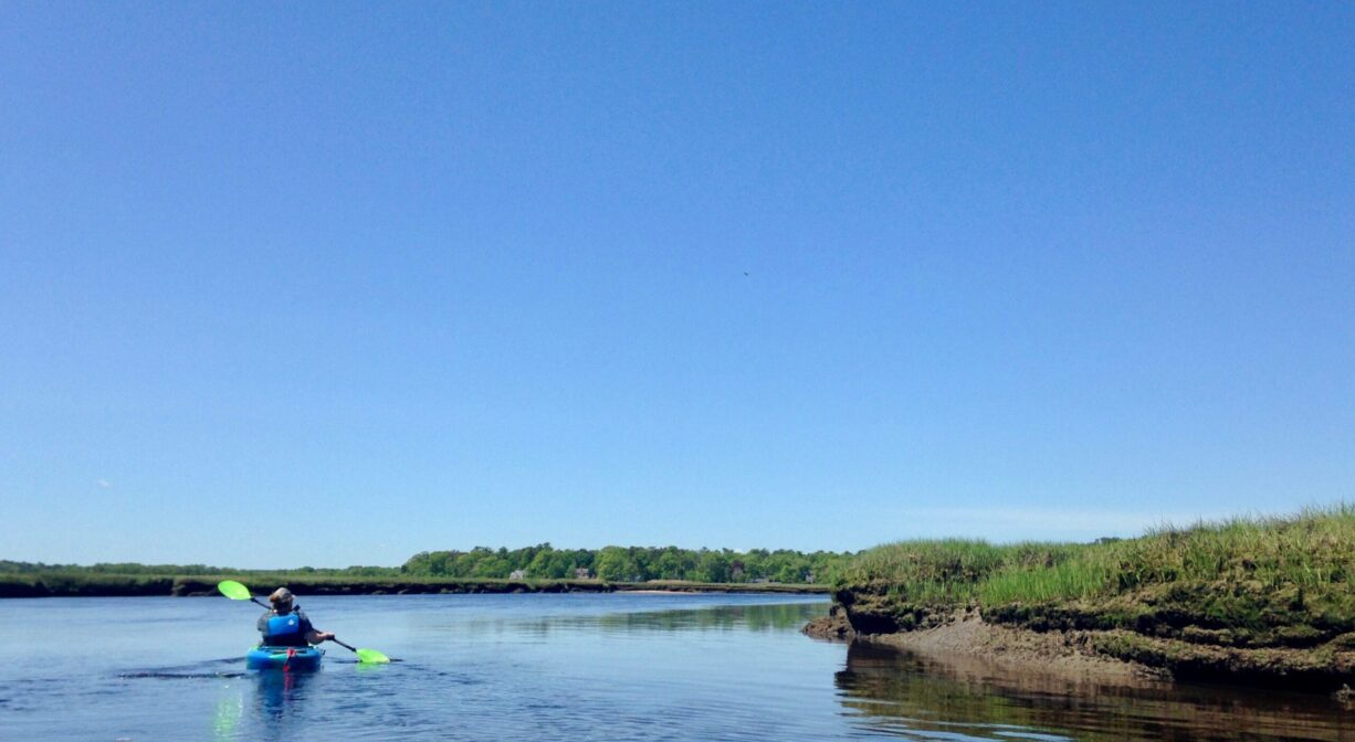
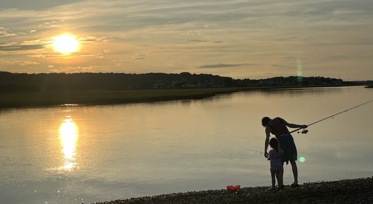
The South River, on the inland side of the property, is a popular access point for paddlers and swimmers. Trails through the sand dunes lead to a sandy beach on the river, with views of Humarock. Rexhame is also the location of the historic marker for Old Mouth, the former (prior to 1898) mouth of the North River. Prior to the 1898 Portland Gale, the area between Rexhame Beach and the southern end of Humarock was the mouth of the North River. It was a major center of activity, since all boats entering and leaving the river passed by. It is now a barrier beach. Look for the historic plaque in the Rexhame Beach parking lot.
Tide Math: High tide on the South River at Rexhame is about 45 minutes after the Boston high tide.
FISHING ADVISORY: It’s important to know that some of our freshwater fisheries are contaminated with mercury, PFAS and/or other concerning substances. The Massachusetts Department of Public Health maintains an online database with up-to-date advisories regarding fish consumption, sorted by location. We recommend you consult this valuable resource when planning a fishing excursion.
Hunting is not permitted on this property.
SWIMMING: Massachusetts routinely checks water quality at public swim spots and shares the data in an online database. Save this link so you can check water quality before you go.
Features
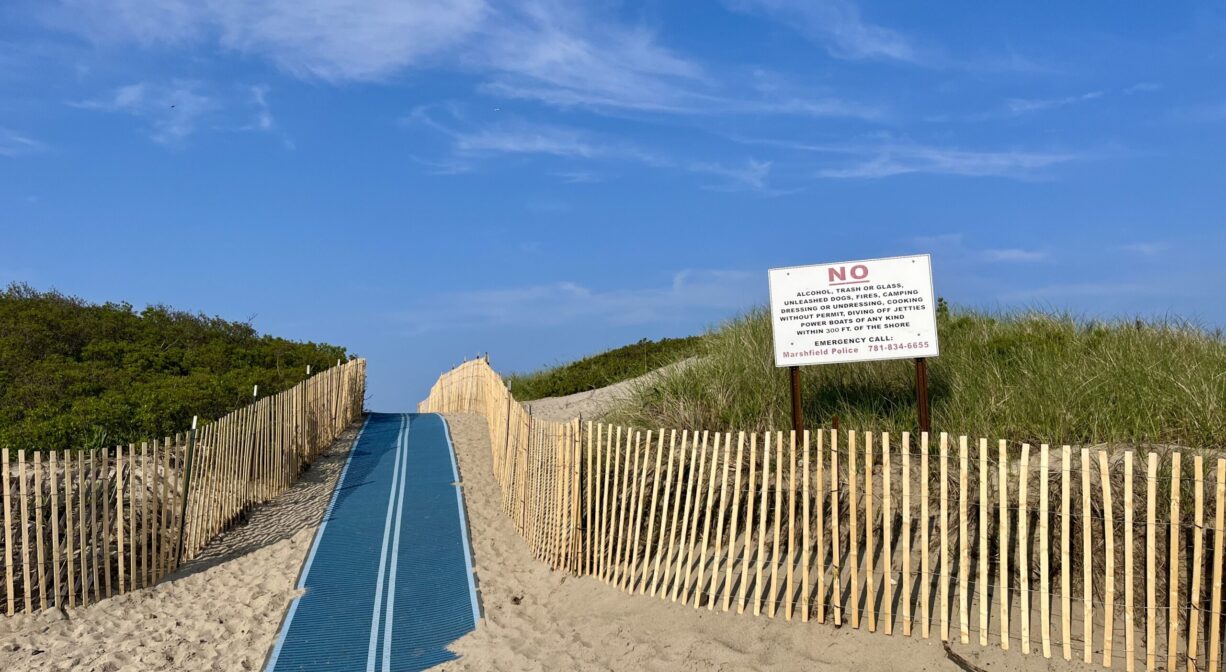
The following items/activities are prohibited on the property: alcoholic beverages, littering, glass, fires, unleashed dogs, camping, dressing/undressing, power boats, water skiing, jet skiing. Raft/float use is subject to safety orders from lifeguards.
Matty K’s 7 Seas Playground, suitable for toddlers, is located in a small fenced-in area next to the concession stand. The playing surface is beach sand. Dogs are not permitted within the playground.
Rexhame is a beautiful sandy beach. On one side of its dunes is the ocean, and on the other side is the South River. The name “Rex-ham” (meaning the king’s village) was used interchangeably with “Marshfield” in the town’s early days. Five families settled Rexhame from 1637 to 1641, and each were given 100 acre grants of land. These were: Thomas & Elizabeth Bourne, Josiah & Margaret Winslow, Robert & Elizabeth Waterman, Joseph & Rachel Beadle, and Kenelm & Ellen Winslow. For 200+ years, Rexhame was home only to the farms of these five original settlers. Modern development began in 1875, with the 87 house lots of Rexhame Terrace.
The Sea Rivers Association sold 5+ acres of the land that’s now Rexhame Beach to the town in 1950. Two years later the public beach opened. A housing boom commenced after 1963 when the Southeast Expressway was extended to Marshfield. The Rexhame area is now bursting with summer cottages, many of which have been converted to year-round homes.
Have you ever wondered why Humarock is part of Scituate, not Marshfield? It’s not attached by land to Scituate. It’s actually contiguous with Marshfield – by land, via the Rexhame Dunes. (It’s also connected to Marshfield by two bridges, on Sea Street and Julian Street.) Before 1898, the mouth of the North River sat at the southern end of Humarock, near present-day Rexhame Beach in Marshfield. Back then, the location of the current river mouth, between Third and Fourth Cliffs, was a narrow barrier beach.
On November 26 and 27, 1898, a nor’easter known as the Portland Gale struck the New England coastline. It is remembered particularly for wreaking havoc on the South Shore and Cape Cod. Named after one of over 100 ships that were wrecked during the course of the storm, the Portland Gale claimed more than 400 lives in under 24 hours. It is considered to be New England’s worst maritime disaster, with widespread destruction of homes, railroad tracks, and bridges.
At the height of storm, a surge on the river washed over the beach between Humarock’s Third and Fourth Cliffs, and out to sea. It was powerful enough to make a permanent cut in the beach. The outgoing river tides continued to flow through what became known as New Inlet to the sea, and the incoming ocean tide, flowed through there to the river. Thus, the North River, with its mouth now three miles farther north, became 3 miles shorter! And the South River – which originally flowed into the North River at Rexhame – became 3 miles longer. The old mouth at Rexhame soon filled in with sand and became part of the beach. It’s now the northern portion of the Rexhame Dunes.
This wasn’t entirely an unwelcome change – at least for some. For years there had been a movement to make a cut in the beach between Third and Fourth Cliffs. Earlier in the century North River shipbuilders had lobbied for a “new inlet” that would make it easier to sail a newly-constructed ship downstream to the ocean. Because the North River was shallow and winding, it often took an entire week to get a ship out to sea. The final few miles of river along Humarock were particularly difficult to navigate. Since it could only accommodate a certain size vessel, it set a limit on the size of the ships that could be built. Could an inlet between Third and Fourth Cliffs alleviate this problem? A petition to the state legislature to fund such a cut was denied, as it would have far too much impact on other river industries, namely agriculture and salt marsh haying.
However . . . in 1843, a group of set out under cover of night and with shovels, picks, and teams of oxen and made a clear cut across the beach. They were unable to complete the task, due to a rock-hard meadow bank beneath the sand. Water flowed through the cut temporarily, but the beach soon filled back in. A similar effort with a dredging machine was made in 1858. There is some speculation that these attempts to relocate the river mouth weakened the resolve of this stretch of beach so that when the Portland Gale arrived in 1898, it was all the more susceptible to the force of the water.
In the years since the Portland Gale, the size of the river mouth has increased fifteen times over. What was once only 200 feet wide and ten feet deep is now 1/2 to 1 mile wide and up to 60 feet deep. The Rexhame Dunes now stand at the site of the old mouth. The dunes rise at least 20 feet above the mean high tide level, helping to enclose one of the more unique landscapes on the South Shore.
The opening of the New Mouth affected agriculture, because of increased flooding. Fields near the river couldn’t be farmed in the same way, or at all. Salinity levels of the marshes increased, salt haying business ceased as more coarse grasses took over, white cedar trees as far as Job’s Landing in Pembroke died. You can still see the dead cedars. Before the coming of the new mouth, the ocean’s high tides flowed to the North River’s 5,000 acres of salt marsh with the spring tides, only twice each month. With the opening of the inlet at Fourth Cliff, the frequency of these high tides increased to twice each day.
While most of the Rexhame Dunes are open to the public, the northernmost section (in Humarock) is privately owned, by the Sea Rivers Association. This group has an interesting history. In 1892 a group of Methodist ministers who met as classmates at Boston University Theological School purchased three farms on the side of Snake Hill (today’s Telegraph Hill), directly across from the mouth of the river. A few years later they also acquired some of the adjacent land that had belonged to Peregrine White and his descendants. Altogether they acquired more than 100 acres. In 1895 they formed an association (first known as the Sea Rivers Club) and divided up the land into plots of equal acreage. Much of it was set aside as common land; this included salt marsh, a section of Humarock Beach, and a portion of what is now Rexhame Beach.
The ministers and their families shared common houses at first and eventually built their own. They planted apple trees and shade trees, and would come to Marshfield in the summertime. These homes, which overlooked what is now the South River and Rexhame Beach, would have been the perfect vantage point to view one probably the most significant geographic change in Marshfield’s recorded history.
One last note: In the summer of 1899, members of the Sea Rivers Club made an attempt to reopen the Old Mouth. With horses and a plow, they dug a channel through the freshly-created beach. For s short time, a narrow stream of water flowed through. However by morning, the channel had filled in again.
This land is within the region of the Massachusett (or Massachuseuk) and Wampanoag Native American tribes. To learn more about local tribes, we encourage you to interact with their members. The Mattakeeset band of the Massachusett, the Massachusett tribe at Ponkapoag, the Mashpee Wampanoag, and the Herring Pond Wampanoag also share information on their websites.
Trail Description
Unmarked but easy-to-follow trails lead from the parking lot through the sand dunes and along the edge of the South River to the Marshfield/Scituate (Humarock) town line. Take a stroll and imagine what this spot looked like prior to 1898, when the river mouth was here. Be sure to stay on established trails! They are often delineated with snow fencing, to protect the fragile dune habitat.
The Marshfield side of the dunes is open to the public. The Scituate side of the dunes is private property (owned by the Sea Rivers Association) and is not open to the public. A line of cedar posts marks the border. Trails continue through over high dunes to the Atlantic Ocean. A short distance to the north is Humarock Beach. While you may be tempted to continue through to Humarock, we advise that you instead follow the trail through up the dunes to Rexhame Beach itself.
The South River at the Rexhame Dunes is a popular spot to launch a canoe, kayak or paddleboard. This requires an approx. 600-foot carry over sand, from the parking lot to the river. Park close to the basketball court, and carry your boat past the metal gate, down the wide path, and then over (to the left) to the river. If paddling downstream into Humarock, be especially careful at the Julian Street Bridge, where the current can be strong due to the tides and the narrowing of the channel caused by the bridge abutments.
Suggested paddling excursions from this location (timing is approximate and depends quite a bit on wind, tide, and your own strength and stamina):
• Put your kayak in the water 1-2 hours before ocean high tide. Ride the rising tide upstream to the Bourne Island Lagoon or the the Kent Park area, and then return to your starting place. (2-3 hours)
• Put your kayak in the water 1 hour before ocean high tide. Explore the creeks that accessible on the other side of the river, a little way upstream or downstream, then return to your starting place. (1-2 hours)
• Stage a second vehicle at Francis Keville Footbridge. Return to Rexhame Beach and put your kayak in the water 2 hours before ocean high tide. Ride the rising tide all the way up to Keville. (1.5-3 hours)
Habitats and Wildlife
There are three distinct habitats on this property — ocean beach, sand dune and salt marsh. In the Rexhame Dunes, you’ll find cedar trees and other seaside-dwelling vegetation such as beach plums, heathers, and deep-rooted dune grass. American Beachgrass acts like glue to hold the dunes together. Snow fence (aka sand fence) helps to control erosion. Red and grey fox can be spotted in the dunes in the early hours. Eastern cottontail rabbits are common along the low shrubbery. Shorebirds are abundant.
Rexhame Beach is a popular fishing spot — both on the dune side (in the South River) and in the ocean, near Beadles Rocks. Striped bass in particular are a common draw for anglers.
The South River originates deep in Duxbury. Its source is in the Round Pond area, and from there it winds unobtrusively through the woods for several miles. Although one can view it from Route 3, and also from both the South River Bog and Camp Wing conservation areas, it remains a narrow and mostly un-navigable stream until it makes its first “public” appearance at Veterans Memorial Park in Marshfield. From there it flows under Route 3A, through South River Park, and behind the playground of South River School, emerging again at Willow Street. By the time it reaches the Francis Keville Footbridge in Marshfield Center, the river is wider, and navigable at most tides. Its course continues as it winds through the marshes, running parallel to Route 139, all the way to Rexhame. From there the river turns northward. It flows for 3 miles between Humarock and the mainland to Fourth Cliff, where it joins the North River at its outlet to the sea.
Just downstream from the Rexhame Dunes, Clapp Creek flows into the South River from the Marshfield side. At higher tides, this is an interesting place to explore. You can paddle quite a distance through the marsh toward Coast Guard Hill.


Historic Site: Yes
Park: No
Beach: Yes
Boat Launch: Yes
Lifeguards: Lifeguards in season.
Size: 43 acres
Hours: Dawn to dusk.
Parking: Ample on-site parking at the end of Standish Street. In season, a Marshfield Beach sticker or fee is required.
Cost: Free with Marshfield Beach sticker. If no sticker, in season fees are: $25 on Monday - Thursday, $30 on Friday & Saturday, $35 on Sundays and holidays, and $5 any day after 5pm. No fee for off-season parking.
Trail Difficulty: Easy
Facilities:
Restrooms 7am-7pm, Memorial Day to Labor Day. Lifeguards: 9am-7pm, Memorial Day to Labor Day. Snack bar 11am-5pm, Memorial Day to Labor Day. Small playground. Bike rack. Picnic table. Trash receptacles. Occasional benches on the trails.
Dogs: Dogs must remain on leash. Always clean up after your dog!
Boat Ramp: No
ADA Access: Accessibility mats, in season.
Scenic Views: Yes
Waterbody/Watershed: South River