
2 Sea St, Marshfield, MA 02050, USA
Owned By: Town of Marshfield
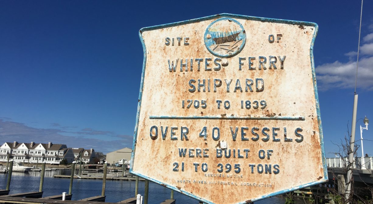
Spanning the South River, the Sea Street Bridge connects Marshfield’s Sea Street to Humarock’s Marshfield Avenue. The bridge was renamed in 1998 to honor Captain Frederick Stanley for his long service to saving lives while captain of the US Life-Saving Station and Coast Guard Station at Humarock. At the western end of the bridge, look for the historical marker for White’s Ferry. One of the earliest shipyards on the North River was located near this spot, as well as a ferry service.
Features
The first Sea Street Bridge was constructed in 1881, the same year that the Hotel Humarock opened for business. It featured stairs on the north side that led down to a dock at the channel opening. The current bridge — which was constructed in 2007-2008 with state funding — is an eight-span pre-cast concrete structure. It was formally dedicated in 1998, to mark the 100th Anniversary of the Portland Gale. As part of the 2007-2008 bridge replacement, the channel underneath was dug deeper and wider, to improve conditions for boat traffic.
The bridge is named for Captain Frederick Stanley, to honor his long service to saving lives while Captain of the US Life-Saving Station and Coast Guard Station at Humarock. The Humarock Life-Saving Station was part of the United States Life-Saving Service, which in 1915 merged with the Revenue Cutter Service to form the US Coast Guard. It was located in at the southern base of Fourth Cliff. Built in 1879 as station #28, it burned to the ground in 1919 and was not rebuilt. The Life-Saving Station had a crew of 7 men and a 25-foot lifeboat. The northern patrol route was across the gravel road on the shingle beach between Fourth and Third Cliffs, all the way up to First Cliff, along the water. The southern route was to the mouth of the river, about 3 miles, near present-day Rexhame Beach.
In 1638, a ferry service was established at or near this spot, at the narrowest place in the North River (now the South River). It provided transportation across the river, between Marshfield and Scituate, for both people and cattle (in separate vessels). At the time, the location was known as New Harbor Marsh. Jonathan Brewster was the first ferryman. He was the son of Elder Brewster of Mayflower fame. He sold the ferry service in 1641 to Barker and Howell. Ralph Chapman later ran the ferry service, and then in 1712 Benjamin White, grandson of Peregrine White, took over. From that point on, it was known as White’s Ferry.
There was a shipyard at White’s Ferry as early as 1705. The sloop Mary & Abigail (40 tons) was built that year. Simeon Keene built ships at White’s Ferry in 1787, beginning with the schooner Neptune (64 tons). Then from 1825-40 the Hall Family (mostly Luke, plus William and Samuel) built ships there. The only steamboat built on the North River was built at White’s Ferry in 1839, the Mattakeesett (21 tons). The steamboat was intended to be put to use towing new vessels downriver, but this proved to be difficult because the winding course of the river did not permit an ample length of tow line. The Mattakeesett was sold and put to use in Boston Harbor instead. White’s Ferry Shipyard also produced spars, sails, cordage and rigging. Ships built upstream were often rigged here, and many also had their masts stepped, before setting out to sea.
The ferry was replaced in 1881-1882 by the bridge from Marshfield to Humarock. The bridge was constructed by The Fourth Cliff Land Company, to whom the town gave a quitclaim deed to “all the land or Hummocks below Fourth Cliff between the North River and the ocean to low water mark.” The bridge was built to service the resort hotel, Hotel Humarock.
In the early days of Plymouth Colony, the Pilgrim Trail, also known as Green Harbor Path, was the primary land-based travel route from Plymouth to Scituate. From North Plymouth, it followed the coastline through Kingston, crossing the Jones River near Rocky Nook at a location known as the Wading Place. It continued through Duxbury, west of today’s Tremont Street/3A, and crossed into Marshfield at Careswell Street. Heading north through Marshfield, it crossed the Green Harbor River near today’s Bourne Park Ave. and crossed the South River at a spot called Valley Bars. From there it proceeded along the base of Snake Hill (Telegraph Hill) to White’s Ferry. After the ferry crossing at what was then the North River (now the South River), it proceeded along Humarock’s barrier beach, crossing into Scituate’s mainland between Fourth and Third Cliffs (the present location of the North River mouth). From there, it led to the Scituate First Church. First established by Native Americans, this route likely existed for centuries before Europeans arrived in the area. It was formally designated by Plymouth Colony in 1637. It was probably the first court-ordered road in America.
This land is within the region of the Massachusett (or Massachuseuk). To learn more about local Native American tribes, we encourage you to interact with their members. The Massachusett tribe at Ponkapoag and the Mattakeeset band of the Massachusett share information on their websites.
Sources for Humarock history include historians Fred Freitas and W. Ray Freden, among others.
Trail Description
No trails, but the bridge is pedestrian-friendly with a broad concrete sidewalk.
Habitats and Wildlife
The South River is a beautiful tidal estuary where wildlife abounds! Paddling or boating on this estuary allows you to go shellfishing, fishing or just exploring. Downstream there are salt marshes and numerous creeks, host to egrets and blue heron. You might even see a bald eagle!
The South River originates deep in Duxbury. Its source is in the Round Pond area, and from there it winds unobtrusively through the woods for several miles. Although one can view it from Route 3, and also from both the South River Bog and the Camp Wing Conservation Area, it remains a narrow and mostly un-navigable stream until just below Veterans Memorial Park. From there it flows through South River Park, behind the playground of South River School, and under the Willow Street and Francis Keville Bridges. Wider at that point, and navigable at most tides, its course winds through the marshes as it runs parallel to Route 139, all the way to Rexhame. From there the river turns northward. It flows for 3 miles between Humarock and the mainland to Fourth Cliff, where it joins the North River at its outlet to the sea.


Historic Site: Yes
Park: No
Beach: No
Boat Launch: No
Lifeguards: No
Hours: Public roadway. Always open.
Parking: Limited public parking on Sea Street and across the bridge on Marshfield Ave.
Cost: Free
Trail Difficulty: Easy
Facilities:
Two historic markers at the western end of the bridge.
Dogs: Dogs must remain on leash. Always clean up after your dog!
Boat Ramp: No
ADA Access: Yes
Scenic Views: Yes
Waterbody/Watershed: South River