
Owned By: Town of Scituate
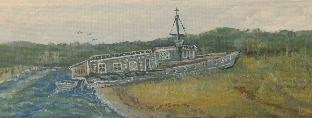
The South River Shipwreck site is located between Tilden Island and the foot of Fourth Cliff in Humarock, in an area generally known as the Hanover Flats. A sunken ship approximately 70 feet long can be seen here, with keel and ribs sometimes in view. Local lore claims it to be either a rum runner or a WWI sub chaser. Water access only.
Note: At high tide, the area known historically as the Hanover Flats is now divided into two pieces. While the northern parcel retains the name “the Hanover Flats,” the southern portion, where the shipwreck is located, no longer has a name. Recent shoaling in the South River may have impacted the visibility of this wreck.
Features
Longtime Marshfield resident W. Ray Freden describes the South River shipwreck as follows. “It was there before 1927. A large square box-like structure was built in the middle, like living quarters. A line of windows could be seen from Central Ave. During the summer, two or three dories or skiffs would be tied to the rear porch, built on the back (stern) of the boat. There was a tall flagpole near the center. I remember it as being grey natural wood with little paint. Many times I passed the remains of the mysterious wreck to go clamming in the area. The ribs stuck up maybe three feet with some planking still attached. One shaft lay in the middle for years.”
There have always been conflicting stories about the history of the mysterious wreck on the Hanover Flats. In Edward Rowe Snow’s story about the Submarine Chaser S-241, published in the Patriot Ledger on 12/11/67, he wrote, “First I was informed that the craft was a rum runner which was trapped during prohibition days under heavy gunfire at half tide on Hanover Flats, after which it was abandoned. . . Then I was told it was . . . a rum chaser which, after a successful career, ended her days on the edge of the North River and went ashore at the Hanover Flats in a gale.” Snow explains that it was actually a submarine chaser that had been converted into a rum runner during Prohibition and operated in the Marshfield-Scituate area for three years, during which time its owner buried hundreds of cases of liquor at various places on the marsh.
What follows is Freden’s detailed description of the ship and its history.
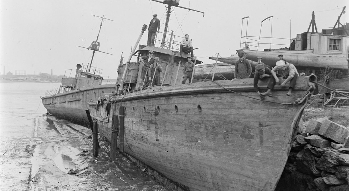
“The New York Launch and Engine Company at Morris Heights, New York built the SC 241 in 1918. Commissioned April 8 1918, and captained by Ensign Robert L. Mills, she was 110 feet long, beam 14’9”, and draft 5’8′. Her speed was 18 kns, powered by three 220 hp gasoline engines, with three props, endurance 1000 nm. Her armament included a 3” gun, two 30 cal. machine guns and one Y gun. The origin of the Submarine Chaser (SC) traces back to World War I and the SC-1 class, wooden hulled, “Splinter Fleet.” The SC was designed for off shore patrols and anti-submarine warfare.
The SC 241 left New London, Connecticut, on May 13,1918, after being outfitted with submarine detectors and wireless telephones. She arrived in Halifax, Nova Scotia, five days later. On July 11, 1918, in the company of SC 247, she sighted a U-boat on her starboard side in a thick fog. At 3:40 p.m., she sighted a torpedo heading for a freight ship, which managed to avoid the torpedo. Pursuing the U-boat, she was able to get less than 35 yards away and then fired depth charges from the “Y” gun. One charge landed 10 yards in front of the periscope, which immediately disappeared. Five seconds later, a terrific explosion followed. It is not known whether the U-boat she destroyed was ever identified.
After the war, the SC 241 was struck from the naval registry. She was sold for scrap on May 11, 1921, to the C.P. Comerford Co. of Lowell, Massachusetts, and stripped of guns, engines and all hardware. Sometime later she was sold to a John F. Smith, and towed by a tug to the South River, where she was then anchored. The Smith family painted the interior in various colors. The SC 241 came with a pilot house and a crow’s nest.
A storm in November 1925 caused the SC 241 to break away from her mooring. Blown across the marsh, she became stranded on the Hanover Flats. The Smith family dug a trench in the marsh and settled the sub-chaser into the south side of the flats. The family added a five-room structure, a rear porch, and a landing on the stern, which faced south. The family used the SC 241 as a summer home for many years. During World War II, the history-making SC 241 was used less, and without care, began to deteriorate. Torched by vandals, she burned to the water line as fire companies watched helplessly from Central Ave. in Humarock. I never heard that anyone was charged with the arson.”
This land is within the region of the Massachusett (or Massachuseuk). To learn more about local Native American tribes, we encourage you to interact with their members. The Mattakeeset band of the Massachusett, and the Massachusett tribe at Ponkapoag, both share information on their websites.
Habitats and Wildlife
The location of this shipwreck is also sometimes described as on the South River, halfway between Ferry Hill and Fourth Cliff.
The South River originates deep in Duxbury. Its source is in the Round Pond area, and from there it winds unobtrusively through the woods for several miles. Although one can view it from Route 3, and also from both the South River Bog and the Camp Wing Conservation Area, it remains a narrow and mostly un-navigable stream until just below Veterans Memorial Park in Marshfield. From there it flows through South River Park, behind the playground of South River School, and under the Willow Street and Francis Keville Bridges. Wider at that point, and navigable at most tides, its course winds through the marshes as it runs parallel to Route 139, all the way to Rexhame. From there the river turns northward. It flows for 3 miles between Humarock and the mainland to Fourth Cliff, where it joins the North River at its outlet to the sea.
Historic Site: Yes
Park: No
Beach: No
Boat Launch: No
Lifeguards: No
Hours: Dawn to Dusk
Parking: Water access only. No public parking.
Cost: Free
Dogs: No
Boat Ramp: No
ADA Access: No
Scenic Views: Yes
Waterbody/Watershed: South River