
THE FOLLOWING IS THE 8TH INSTALLMENT OF A 10-PART SERIES ON THE HISTORY OF THE ORGANIZATION.
Restoring Flows and Habitats
By Jim Glinski, Scituate
The NSRWA’s 2005 strategic plan announced that one of its primary goals was “to restore water quality, water quantity, and critical habitats.” To achieve that goal, the NSRWA sought to open the shellfish beds for harvest in areas of the rivers for more extended periods, worked to improve streamflows and habitat in the First Herring and Third Herring Brooks, and decreased the amount of polluted stormwater flowing into the rivers.
Restoring Shellfish Beds
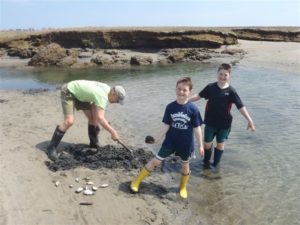
Throughout most of its existence, the NSRWA has reduced pollution sources to restore water quality so that citizens can harvest shellfish from their rivers. NSRWA campaigns, such as Harvest 95, contributed to the North River shellfish beds re-opening for limited periods. Still, the ultimate goal is to have water quality that supports year-round shellfishing. In the first two decades of this century, NSRWA made more progress on this issue.
A breakthrough for the rivers’ shellfish beds occurred in 2011 when for the first time in 20 years, 313 acres of shellfish beds on the South River were reopened to recreational shellfishing from December 1 to May 30, culminating decades of work by the NSRWA to restore water quality in the South River. The Town of Marshfield’s harbormaster, Mike DiMeo, played a significant role in getting the state’s Division of Marine Fisheries out to sample the water quality in support of opening the shellfish beds. As water quality continued to improve, in 2013 shellfish beds were opened one month earlier on November 1. In 2019, another month earlier, on October 1, getting closer to achieving the goal of year-round shellfish harvesting on the rivers. In total, the NSRWA, working with many partners over many years, worked to improve water quality and open over 600 acres of shellfish beds for recreational use in the North and South Rivers.
For the last 25 years, the NSRWA has monitored water quality at ten sites on the North and South Rivers through its citizen science RiverWatch Water Quality Monitoring Program. From the beginning of June to the end of August, volunteers test the ten sites for both swimming and shellfishing standards every other week. The data are the only long-term monitoring of the water quality of the rivers.
 Over the years, RiverWatch counts have documented a decrease in bacteria counts in the rivers as a result of Title V septic improvements, improved sewage treatment, and reductions in stormwater runoff, all advocated for by the NSRWA. Yet, the remaining water pollution has proven difficult to source and thus fix. In 2019, the NSRWA received a grant from the Massachusetts Department of Environmental Protection to expand its bacterial monitoring program. These funds allowed more frequent sampling of shellfish beds and tributaries upstream from our RiverWatch stations on the North River. The sampling station furthest upstream, at the Old Washington Street Bridge in Hanover and Pembroke, frequently exceeds the swimming bacterial standard. Testing in upstream tributaries in Hanover and Rockland, such as the Drinkwater and Indian Head Rivers, would help to locate the source of pollution. The data collected from these tributaries suggested a mix of potential stormwater (wet weather) and wastewater (dry weather) sources of bacteria similar to the Old Washington Street Bridge site data. The search continues to find these remaining pollution sources.
Herring Restoration Efforts
Another indication of the North and South Rivers’ improving health is the restoration of habitat for the herring population, which for centuries had spawned in the rivers’ tributaries but whose population has decreased significantly and all but disappeared in many locations. In fact, in 1996, the NSRWA’s first herring count on the First Herring Brook showed no herring at all! In the 17th century, herring were an important part of the colonist’s diet and bait for larger game fish. As Sara Grady, NSRWA watershed ecologist noted, “river herring are a crucial link in the food chain in our estuaries and ocean. As a forage fish, they provide food for many species of predatory fish – some of great recreational and commercial importance, like striped bass and bluefish – as well as birds, like ospreys and herons.” They were also crucial to the ecology of coastal streams, transferring vast stores of nutrients between the ocean and the rivers.
While there are over 60 known dams throughout the watershed to the North and South Rivers, the NSRWA has had some success in restoring herring on two tributaries to the North River, the First Herring Brook in Scituate and the Third Herring Brook in Hanover/Pembroke. Efforts have also begun on dams along the mainstem of the South River and Indian Head Rivers and will undoubtedly unfold in the next decade. According to NSRWA Executive Director Samantha Woods, “Restoring natural fish runs to the North and South Rivers and its tributaries will require that we collectively overcome three very different challenges:
- The various dams and other impediments along the brooks must be removed or modified to allow fish passage;
- Water must be better conserved, particularly in the summer when demand doubles due to lawn watering and pools; and
- Stormwater runoff from paved surfaces must be reduced, allowing more water to seep into the ground and recharge the brooks during times of low flows.”
While the causes of the unhealthy herring runs were similar for both First Herring and Third Herring Brooks, the solutions for each are different. In Scituate’s First Herring Brook, the dams and their reservoirs located on the First Herring Brook are essential to the town’s drinking water supply and subject to state water management permits. Because demand for water in Scituate doubles in the summer, often for nonessential needs like irrigation, Scituate does not release water downstream, preventing young herring from getting out of the reservoirs.
The Third Herring Brook’s primary issue is three dams that are relics of the industrial revolution, which are not part of the public drinking supply and are privately owned and in disrepair. Therefore, restoration of Third Herring Brook requires working with each dam owner to repair or remove their dams.
Restoring Herrings Runs on First Herring Brook

The NSRWA’s efforts to restore streamflow and fish runs for First Herring Brook would be aided by several factors. The first was that Scituate needed support from the NSRWA for its water management permit from the state’s Department of Environmental Protection, which prompted the town to support efforts to restore herring to the system. This was indicative of the new cooperative relationship between the Town of Scituate and the NSRWA. They now were working closely to find common ground on solutions to the First Herring Brook issues after the years of confrontation over the town’s wastewater treatment plant. Scituate selectman Rick Murray noted the town was “delighted that the NSRWA is working closely… helping us fulfill the obligations of our drinking water permit.” In June 2012, this partnership resulted in Scituate receiving the Sustainable Communities Award from the Gulf of Maine Council on the Marine Environment to restore fish habitat and natural streamflow in the First Herring Brook.
Another positive factor helping to restore fish runs for the First Herring Brook was the existence, as described earlier in this history, of the First Herring Brook Watershed Initiative (FHBWI), an affiliate of the NSRWA based in Scituate and focused on the First Herring Brook watershed. The FHBWI provided volunteers to monitor habitat and streamflow. Their efforts identified the main challenge to herring restoration in the First Herring Brook, which was to provide enough water for in-migration of adult alewife herring in the spring, and especially for out-migration of juvenile herring in late summer and fall. In 2010, the NSRWA, FHBWI, Mass Bays, and other partners issued a report which demonstrated that a combination of new fish ladders, new water supply sources, and water conservation could restore streamflows in the brook to support migrating herring.
 Since the 2010 report, continuous progress has been made to improve conditions in the First Herring Brook. In 2011, the NSRWA and its partners worked with the Town of Scituate to adopt a lawn watering restrictions, saving approximately 300,000 gallons of water per day! The water savings enabled the Scituate Water Department to operate the fish ladder at Old Oaken Bucket Pond for the first time in decades. In April 2012, NSRWA volunteer herring counters saw the first herring in the fish ladder in recent memory. However, the number of herring remained small, with only 6 herring counted in the spring of 2013.
Since then, a series of state grants funded continued progress in this  restoration effort. The grants paid for water conservation signage, new water meters, water demand analysis, improvements to the fish ladder at Old Oaken Bucket Pond, and an engineering study to get herring up to the upper reservoir where there is the potential for 70 acres of additional spawning habitat. As Scituate Special Projects Manager Al Bangert wrote in 2017, “Our partnership with the NSRWA and the state and federal government partners they bring has allowed our town to access hundreds of thousands of dollars to plan and make changes to our water supply that save water for people and restore fish passage for river herring.” The next step, which the town and the NSRWA are currently working on, is to restore fish passage to the upper reservoir by raising the reservoir 1.5 feet, providing drought resiliency to the town, and restored access to spawning habitat.
Restoring Herring in Third Herring Brook: Dam Removal
As noted earlier, the solution to restoring the herring run in Third Herring Brook is different than those for First Herring Brook. There were three dams on the Third Herring Brook as you head upstream from the brook’s confluence with the North River. These dams are the Tack Factory dam, Mill Pond dam, Peterson’s Pond dam, and the earthen dam and culvert at Jacobs Pond. The removal of these impediments plus the placement of a fish ladder into Jacobs Pond will restore 10 miles of free-flowing stream and 60 acres of spawning habitat. The removal of these dams required the NSRWA to confront four different situations.

The first obstruction was the Tack Factory dam in Hanover, owned by the Cardinal Cushing Center. Initially built in 1677 to power a grist mill, the dam was rebuilt several times over its existence, most recently in 1928. By the early 2000s, the Massachusetts Office of Dam Safety classified the dam in poor and failing condition. In 2002, the NSRWA and its Mass Bays partner worked with the Cardinal Cushing Center to acquire funding, from state and federal agencies, for engineering and feasibility studies to determine the options for dealing with the dam. However, the project came to a halt when abutting homeowners who overlooked the pond were generally not supportive of the dam’s removal. Despite these concerns, the dam would be removed in January 2017, the culmination of 15 years of planning, negotiating, and raising $450,000 in grant funding. As highlighted in the April 2017 edition of its newsletter RiverWatch, “The removal of the Tack Factory Dam is a huge milestone in restoring our rivers’ health” opening 8.4 miles of the brook to migrating fish populations for the first time in 342 years!

The second obstruction on Third Herring Brook was the Mill Pond dam owned by the South Shore YMCA in Hanover. The original dam was built in the early 1700s, with the latest dam rebuilt in 1890. The partial collapse of this dam in 2001 provided the catalyst for the Third Herring Brook Restoration project; however, similar to downstream, the abutters at this pond were vocally opposed, and the local Norwell Conservation Commission denied the permits to remove it.
Being thwarted at these two dam sites in the early 2000s, the NSRWA embarked upon an education campaign regarding the plight of the herring. As part of the campaign, they enlisted volunteers to count herring at this brook and others throughout the watershed to understand the dams’ issues. In 2010 the Mother’s Day storm breached the South Shore YMCA dam providing another opportunity to remove it. However, this time, the public and the local conservation commissions were better informed about the benefits of dam removal not only for herring but other fish and the general health of the rivers.
Finally, in 2014 after assisting the Y in fundraising for the project, the Mill Pond dam became the first dam ever to be removed from the watershed. In 2017, in combination with the removal of the Tack Factory dam, these two dam removals opened 86% of the Third Herring Brook habitat to migrating fish.

The third obstruction on the Third Herring Brook is the Peterson’s Pond dam, owned by the Hanover Mall. This dam’s exact age is unknown, although there has been a dam in this location since the 1700s. This dam, like so many of these relics from the industrial revolution, is deteriorated and failing, having outlived its original purpose and the owners have no incentive to repair.
The NSRWA has been involved with the Hanover Mall since its construction in the early 1970s, when it successfully negotiated with the mall to provide stewardship for the brook’s water quality, getting it to not use road salts in the winter and to clean up trash and debris in the brook. In 2004, when the mall went through the permitting process of expanding its cinema complex, the NSRWA encouraged the mall’s owners to add stormwater management practices to improve the habitat in their part of the brook. The mall has recently come under new ownership, Peco Real Estate Partners, which is planning to redevelop the property completely. The redevelopment project provided a golden opportunity for the NSRWA to work with the new owner to remove their dam. The removal of the Peterson’s Pond dam is currently underway in the fall and winter of 2020-21!
The last obstruction on the Third Herring Brook is the earthen dam and culvert under Route 123 at Jacob’s Pond in Norwell. This dam was built around 1730 by the Jacobs brothers for a grist mill that remained until the early 1900s, creating the well-known Jacobs Pond. Because of the importance of Jacobs Pond for local recreation, it is not a candidate for removal. The hope is that the NSRWA can partner with the Massachusetts Highway Department to construct a fish ladder that will enable herring to pass into Jacobs Pond, providing access to 60 acres of spawning habitat.
 As the 2019 statistics on River Herring Runs on the South Shore demonstrate (see chart) where passage has improved giving herring greater access to habitat the numbers of herring have increased. Unfortunately, many herring runs are still limited by a lack of access, especially by dams but also a lack of appropriate streamflow.
Restoring Rivers for Brook Trout
Another obstacle preventing the free passage of fish in the streams of the watershed is culverts. One of these culverts was in the Iron Mine Brook, which flows into the Indian Head River just below Luddam’s Pond Park and the Indian Head dam and fish ladder in Hanover. The brook is home to a small population of native eastern brook trout, whose cold water habitat was blocked by two culverts. Working with several pro-bono partners, including Ivas Wetland Environmental, Trout Unlimited, and the Massachusetts Division of Fisheries and Wildlife, the NSRWA received the necessary permits to remove the culverts. In November 2016, the Town of Hanover DPW removed the culverts, replanted the stream banks with native vegetation, and poured concrete support pads for a wooden footbridge over the steam built by volunteers, opening up another ½ mile of stream habitat for native fish.
I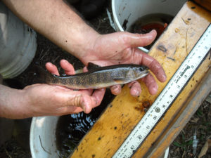 n 2018, NSRWA/MassBays ecologist Sara Grady, Massachusetts Division of Fisheries and Wildlife biologist Steve Hurley and the members of Trout Unlimited and Sea Run Brook Trout discovered that native eastern brook trout were using the Third Herring Brook in the area where the Tack Factory Pond dam had been removed in 2017. They inserted electronic tags in the fish and discovered that they were using the mainstem of the brook for the first time in hundreds of years. It appears that the removal of the dam had caused the brook’s water temperature to cool down enough to accommodate the brook trout. This finding resulted in the entire Third Herring Brook being officially protected as a Cold Water Fisheries Resource. This designation means that any future development or redevelopment along Third Herring Brook will have to meet higher environmental standards for stormwater runoff, the major source of pollution for the watershed’s streams and rivers.
Combating Stormwater Runoff

Stormwater pollution is the result of rain washing over the landscape and carrying dirt, oil, fertilizer, pesticides, animal waste, and many other pollutants from streets, lawns, and farms into the waters of the watershed. Development in the watershed has increased the paving over of natural areas. The paved surfaces of parking lots, driveways, and roads prevent rainwater from slowly soaking into the ground but instead directs rainwater into gutters, culverts, and drains that direct polluted water into streams, wetlands, lakes, and rivers sometimes causing parts of the rivers to be unfit for swimming or shellfishing. Over the past two decades, the NSRWA and the Mass Bays Program have worked with watershed communities to receive funding from the state’s Department of Environmental Protection and Coastal Zone Management to assist in the cleanup of stormwater pollution. One grant provided $356,000 to purchase a new street sweeper to be shared by the towns of Hanover, Pembroke, and Hanson, which cleans up sediment and debris from their streets, preventing it from entering into watershed waterways. Many others, too many to list here, have resulted in upgrades to infrastructure throughout the towns in the watershed.
Beyond seeking funding for our cash strapped DPWs to upgrade infrastructure, another method to combat stormwater pollution is to work with towns to pass stormwater bylaws. Overcoming opposition from the town’s selectmen, in the spring of 2008, Scituate town meeting passed the Scituate Stormwater bylaw, thanks to support from the many NSRWA members from Scituate who supported it. The bylaw requires a stormwater permit for any projects that will disturb more than 15,000 sq ft on any undeveloped parcel or a net increase of 25% or more impervious area on already developed parcels and put Scituate in compliance with the Clean Water Act. The NSRWA continues to provide assistance and encouragement to other towns in the watershed to improve their dealing with polluted stormwater runoff and just this year helped the town of Norwell to pass a stormwater bylaw that will reduce pollution and recharge local groundwater.
To read other installments of the NSRWA’s History visit our History Blog.