325 Standish St, Marshfield, MA 02050, USA
https://www.marshfieldpolice.org/marshfield-beaches/pages/rexhame-beach
Owned By: Town of Marshfield / Sea Rivers Association
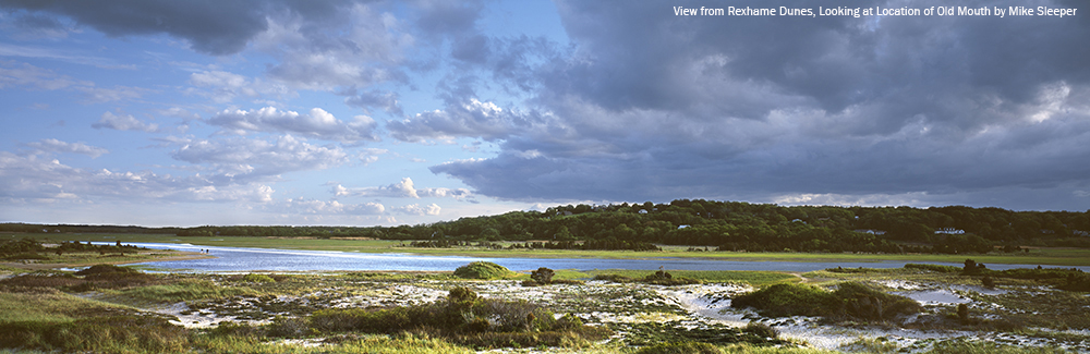
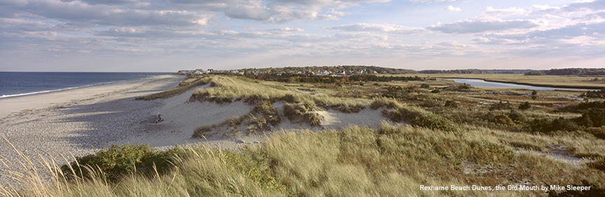
Prior to the 1898 Portland Gale, the area between Marshfield’s Rexhame Beach and the southern end of Humarock was the mouth of the North River. It was a major center of activity, since all boats entering and leaving the river passed by. It is now a barrier beach. Look for the historic plaque in the Rexhame Beach parking lot.
Take a stroll through the dunes and along the South River, and imagine what this spot looked like prior to 1898. Be sure to stay on established trails! Please note that the posts at the northern end of the property mark the town line, and that the area beyond that, in Humarock, is privately owned by the Sea Rivers Association.
Features
Have you ever wondered why Humarock is part of Scituate, not Marshfield? It’s not attached by land to Scituate. It’s actually contiguous with Marshfield – by land, via the Rexhame Dunes. (It’s also connected to Marshfield by two bridges, on Sea Street and Julian Street.) Before 1898, the mouth of the North River sat at the southern end of Humarock, near present-day Rexhame Beach in Marshfield. Back then, the location of the current river mouth, between Third and Fourth Cliffs, was a narrow barrier beach.
On November 26 and 27, 1898, a nor’easter known as the Portland Gale struck the New England coastline. It is remembered particularly for wreaking havoc on the South Shore and Cape Cod. Named after one of over 100 ships that were wrecked during the course of the storm, the Portland Gale claimed more than 400 lives in under 24 hours. It is considered to be New England’s worst maritime disaster, with widespread destruction of homes, railroad tracks, and bridges.
At the height of storm, a surge on the river washed over the beach between Humarock’s Third and Fourth Cliffs, and out to sea. It was powerful enough to make a permanent cut in the beach. The outgoing river tides continued to flow through what became known as New Inlet to the sea, and the incoming ocean tide, flowed through there to the river. Thus, the North River, with its mouth now three miles farther north, became 3 miles shorter! And the South River – which originally flowed into the North River at Rexhame – became 3 miles longer. The old mouth at Rexhame soon filled in with sand and became part of the beach. It’s now the northern portion of the Rexhame Dunes.
This wasn’t entirely an unwelcome change – at least for some. For years there had been a movement to make a cut in the beach between Third and Fourth Cliffs. Earlier in the century North River shipbuilders had lobbied for a “new inlet” that would make it easier to sail a newly-constructed ship downstream to the ocean. Because the North River was shallow and winding, it often took an entire week to get a ship out to sea. The final few miles of river along Humarock were particularly difficult to navigate. Since it could only accommodate a certain size vessel, it set a limit on the size of the ships that could be built. Could an inlet between Third and Fourth Cliffs alleviate this problem? A petition to the state legislature to fund such a cut was denied, as it would have far too much impact on other river industries, namely agriculture and salt marsh haying.
However . . . in 1843, a group of set out under cover of night and with shovels, picks, and teams of oxen and made a clear cut across the beach. They were unable to complete the task, due to a rock-hard meadow bank beneath the sand. Water flowed through the cut temporarily, but the beach soon filled back in. A similar effort with a dredging machine was made in 1858. There is some speculation that these attempts to relocate the river mouth weakened the resolve of this stretch of beach so that when the Portland Gale arrived in 1898, it was all the more susceptible to the force of the water.
In the years since the Portland Gale, the size of the river mouth has increased fifteen times over. What was once only 200 feet wide and ten feet deep is now 1/2 to 1 mile wide and up to 60 feet deep. The Rexhame Dunes now stand at the site of the old mouth. The dunes rise at least 20 feet above the mean high tide level, helping to enclose one of the more unique landscapes on the South Shore.
The opening of the New Mouth affected agriculture, because of increased flooding. Fields near the river couldn’t be farmed in the same way, or at all. Salinity levels of the marshes increased, salt haying business ceased as more coarse grasses took over, white cedar trees as far as Job’s Landing in Pembroke died. You can still see the dead cedars. Before the coming of the new mouth, the ocean’s high tides flowed to the North River’s 5,000 acres of salt marsh with the spring tides, only twice each month. With the opening of the inlet at Fourth Cliff, the frequency of these high tides increased to twice each day.
While most of the Rexhame Dunes are open to the public, the northernmost section is privately owned, by the Sea Rivers Association. This group has an interesting history. In 1892 a group of Methodist ministers who met as classmates at Boston University Theological School purchased three farms on the side of Snake Hill (today’s Telegraph Hill), directly across from the mouth of the river. A few years later they also acquired some of the adjacent land that had belonged to Peregrine White and his descendants. Altogether they acquired more than 100 acres. In 1895 they formed an association (first known as the Sea Rivers Club) and divided up the land into plots of equal acreage. Much of it was set aside as common land; this included salt marsh, a section of Humarock Beach, and a portion of what is now Rexhame Beach.
The ministers and their families shared common houses at first and eventually built their own. They planted apple trees and shade trees, and would come to Marshfield in the summertime. These homes, which overlooked what is now the South River and Rexhame Beach, would have been the perfect vantage point to view one probably the most significant geographic change in Marshfield’s recorded history.
One last note: In the summer of 1899, members of the Sea Rivers Club made an attempt to reopen the Old Mouth. With horses and a plow, they dug a channel through the freshly-created beach. For s short time, a narrow stream of water flowed through. However by morning, the channel had filled in again.
This land is within the region of the Massachuseuk (or Massachusett) and Wampanoag Native American tribes.
Trail Description
Most of the Rexhame Dunes are open to the public. Begin your walk in the Rexhame Beach parking lot, and you will find a few different trails to explore. Please note that the posts at the northern end of the property mark the town line, and that the area beyond that, in Humarock, is privately owned by the Sea Rivers Association. While you may be tempted to continue through to Humarock, we advise that you instead follow the trail through up the dunes to Rexhame Beach itself.
Habitats and Wildlife
In the Old Mouth and the adjacent Rexhame Dunes, you’ll find cedar trees and other seaside dwelling vegetation such as beach plums, heathers, and deep-rooted dune grass. American Beachgrass acts like glue to hold the dunes together. Snow fence (aka sand fence) helps to control erosion.
Red and grey fox can be spotted in the dunes in the early hours. Eastern cottontail rabbits are common along the low shubbery. Shorebirds are abundant.
The South River originates deep in Duxbury. Its source is in the Round Pond area, and from there it winds unobtrusively through the woods for several miles. Although one can view it from Route 3, and also from both the South River Bog and the Camp Wing Conservation Area, it remains a narrow and mostly un-navigable stream until just below Veterans Memorial Park. From there it flows through South River Park, behind the playground of South River School, and under the Willow Street and Francis Keville Bridges. Wider at that point, and navigable at most tides, its course winds through the marshes as it runs parallel to Route 139, all the way to Rexhame. From there the river turns northward. It flows for 3 miles between Humarock and the mainland to Fourth Cliff, where it joins the North River at its outlet to the sea.
Just downstream from the Rexhame Dunes, and across the river from the Old Mouth, Clapp Creek flows into the South River (from the Marshfield side). At higher tides, this is an interesting place to explore. You can paddle quite a distance through the marsh toward Coast Guard Hill.


Historic Site: Yes
Park: No
Beach: Yes
Boat Launch: No
Lifeguards: No
Size: 5 acres
Hours: The Rexhame Dunes are open to the public, however the section of the dunes north of the town line is not open to the public.
Parking: Parking available at Rexhame Beach. Free with Marshfield Beach sticker. If no sticker, in season fees are: $25 on Monday - Thursday, $30 on Friday & Saturday, $35 on Sundays and holidays, and $5 any day after 5pm.
Cost: Free
Trail Difficulty: Easy
Facilities:
Bike rack and trash receptacles near the entrance gate. Rexhame Beach offers seasonal restrooms and concessions, as well as a foot washing station.
Dogs: Dogs must remain on leash. Scoop the poop!
Boat Ramp: No
ADA Access: No
Scenic Views: Yes
Waterbody/Watershed: South River